Colorado State Map
Home Page > United States Map > Colorado State Map
About Colorado State
Colorado is a state located in the western part of the United States. Here are some key points about Colorado:
Capital and Major Cities
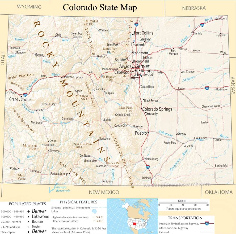
The capital of Colorado is Denver, which is also the largest city in the state. Other major cities include Colorado Springs, Aurora, Fort Collins, and Boulder.
Geography
Colorado is known for its diverse geography, featuring the Rocky Mountains, high plains, plateaus, and desert lands. The state is often referred to as the "Centennial State" because it became a state in the centennial year of the United States, 1876.
Economy
Colorado has a diverse and robust economy. Major industries include agriculture, mining, manufacturing, tourism, and technology. The state is home to a thriving tech industry, particularly in the Denver-Boulder area, which has become known as the "Silicon Mountain."
Outdoor Recreation
Colorado is a paradise for outdoor enthusiasts. The Rocky Mountains offer opportunities for skiing, hiking, mountain biking, and other outdoor activities. The state is famous for its national parks, including Rocky Mountain National Park, Mesa Verde National Park, and Great Sand Dunes National Park.
Education
Colorado is home to several prominent universities and institutions, including the University of Colorado system, Colorado State University, and the Colorado School of Mines.
Culture and Lifestyle
The state has a vibrant cultural scene with numerous museums, art galleries, and theaters. Denver, in particular, has a rich cultural life. Colorado is known for its laid-back and outdoorsy lifestyle. The state has a reputation for promoting a healthy and active way of life.
Weather
The weather in Colorado can vary greatly depending on the region. In the mountains, winters can be cold with heavy snowfall, while the eastern plains experience a more arid climate.
Wildlife
Colorado is home to a diverse range of wildlife, including elk, deer, bighorn sheep, black bears, and mountain lions (Cougars).
Legalization of Marijuana
Colorado is one of the first states in the U.S. to legalize the recreational use of marijuana, and this has had economic and social implications.
History
Colorado has a rich history, including its role in the Gold Rush of the 19th century, the development of the railroad, and its Native American heritage.
Overall, Colorado is a state known for its stunning landscapes, outdoor recreational opportunities, diverse economy, and a culture that embraces both urban and natural lifestyles.
A large detailed map of Colorado State
This is a large detailed map of Colorado State.
View our Colorado State county map
from the National Atlas of the United States
United States Department of the Interior
Colorado State Map
The electronic map of Colorado State that is located below is provided by Google Maps. You can "grab" the Colorado State map and move it around to re-centre the map. You can change between standard map view and satellite map view by clicking the small square on the bottom left hand corner of the map. Satellite map view utilizes orbiting satellite or aerial high resolution photography to display images of the map location to street level detail (really quite amazing). Standard map view shows a traditional street map (also known as a road map). You can use the zoom buttons on the bottom right hand side of the map to zoom in or out to street level detail. We have maps for most towns and cities in the US, so click on the United States Maps link to see more American online maps.