Alabama State Map
Home Page > United States Maps > Alabama State Maps
About Alabama State
Alabama is a state located in the southeastern region of the United States. It is known for its rich history, diverse culture, and beautiful landscapes. Here are some key aspects of the State of Alabama:
Geography
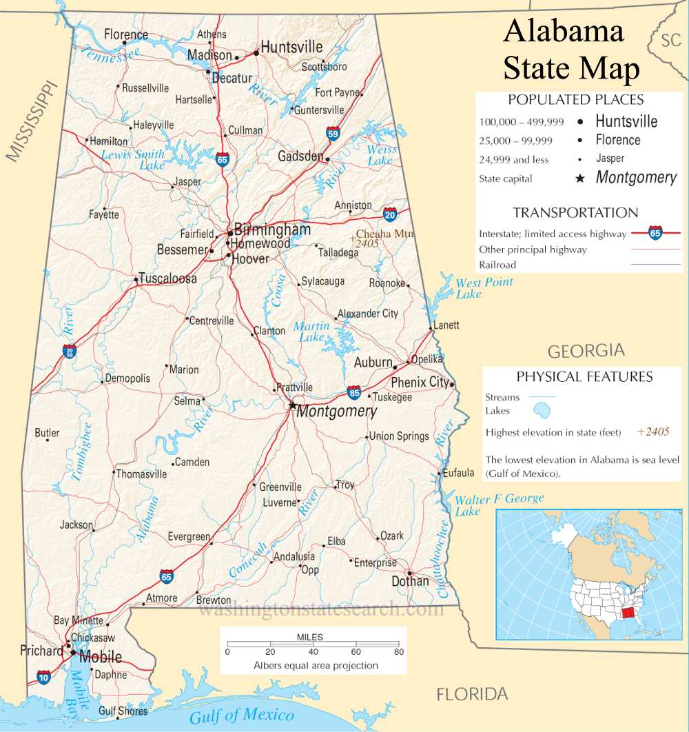
Alabama is bordered by Tennessee to the north, Georgia to the east, Florida to the south, and Mississippi to the west. It also has a coastline along the Gulf of Mexico, offering access to beautiful beaches and warm, tropical weather.
Capital
Montgomery is the capital city of Alabama. The largest city in the state is Huntsville, which is known for its strong emphasis on technology, aerospace, and scientific research.
History
Alabama has a significant place in American history. It was a center of the Civil Rights Movement in the 1950s and 1960s, with notable events like the Montgomery Bus Boycott and the Selma to Montgomery marches taking place in the state. Alabama was also a major player in the cotton industry during the antebellum period and played a pivotal role in the Civil War.
Economy
Alabama's economy is diverse, with industries ranging from manufacturing and aerospace to agriculture and tourism. Major companies like Mercedes-Benz, Honda, and Hyundai have manufacturing facilities in the state, making it an important hub for the automotive industry.
Culture
Alabama boasts a rich cultural heritage, with influences from Native American, African American, and European traditions. The state is known for its music, including blues, jazz, and country. Notable musicians like Hank Williams, Nat King Cole, and W.C. Handy hail from Alabama.
Education
Alabama is home to several universities and colleges, including the University of Alabama, Auburn University, and the University of Alabama at Birmingham. These institutions offer a wide range of academic programs and contribute to the state's educational and research landscape.
Natural Beauty
Alabama's landscape is diverse, featuring mountains in the northern part of the state, fertile plains in the central region, and a coastal region along the Gulf of Mexico. Outdoor enthusiasts can enjoy activities such as hiking, fishing, and water sports in Alabama's many natural parks and waterways.
Tourism
The state's natural beauty and historical sites make it a popular destination for tourists. The Gulf Coast attracts visitors with its beautiful beaches, and historical sites like the USS Alabama Battleship Memorial Park and Civil Rights landmarks draw history enthusiasts.
Sports
Alabama is passionate about college football, and the rivalry between the University of Alabama and Auburn University is a major part of the state's sports culture. The Alabama Crimson Tide and the Auburn Tigers have strong football programs and compete in the SEC West division.
Politics
Alabama has a conservative political landscape, with a history of Republican dominance in recent years. It plays a significant role in national elections and has sent prominent politicians to the U.S. Congress.
In summary, Alabama is a state with a rich cultural heritage, a diverse economy, and a mix of urban and rural landscapes. Its historical significance and contributions to American culture make it a unique and interesting part of the United States.
A large detailed map of Alabama State
This is a large detailed map of Alabama State. There are links to street maps of Alabama's 10 largest cities near the bottom of the page.
View our Alabama State county map
from the National Atlas of the United States
United States Department of the Interior.
Alabama State Map
The electronic map of Alabama State that is located below is provided by Google Maps. You can "grab" the Alabama State map and move it around to re-centre the map. You can change between standard map view and satellite map view by clicking the small square on the bottom left hand corner of the map. Satellite map view utilizes orbiting satellite or aerial high resolution photography to display images of the map location to street level detail (really quite amazing). Standard map view shows a traditional street map (also known as a road map). You can use the zoom buttons on the bottom right hand side of the map to zoom in or out to street level detail. We have maps for most towns and cities in the US, so click on the United States Maps link to see more American online maps.
Auburn | Birmingham | Decatur | Dothan | Florence | Gadsden | Hoover | Huntsville | Montgomery | Tuscaloosa