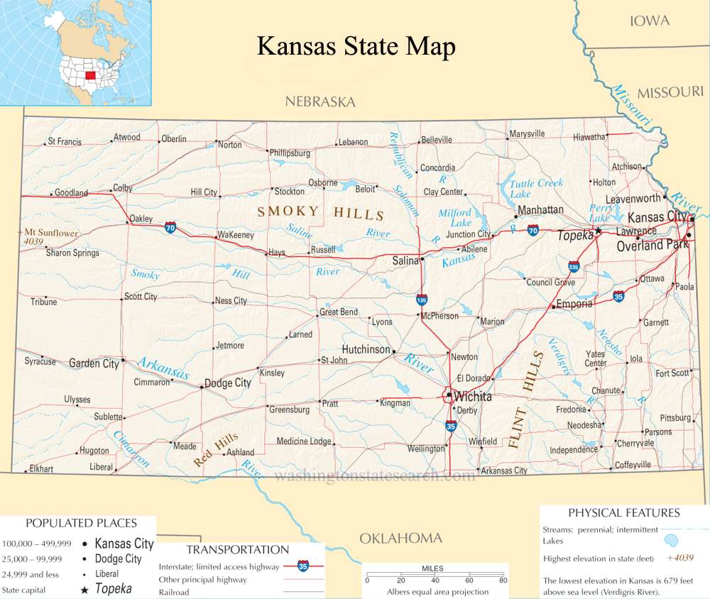
Kansas State Map
Home Page > United States Map > Kansas State Map
About Kansas State
Kansas is a state located in the Midwestern region of the United States. Here are some key aspects and characteristics of the state:
Capital and Largest City
- Capital: Topeka
- Largest City: Wichita
Geography
- Kansas is known for its vast plains and is often referred to as the "Sunflower State."
- The state is part of the Great Plains region and is characterized by flat landscapes, with rolling hills in some areas.
Nickname
- Kansas is often referred to as the "Sunflower State" due to the prevalence of wild sunflowers that grow in the state.
Economy
- Agriculture has historically been a cornerstone of Kansas' economy. The state is a major producer of wheat, sorghum, and cattle.
- Besides agriculture, Kansas has a diverse economy with industries such as aviation, manufacturing, and oil and gas production.
Education
- The state is home to many universities, including the University of Kansas in Lawrence and Kansas State University in Manhattan.
History
- Kansas played a pivotal role in U.S. history, particularly during the period leading up to the Civil War. The Kansas-Nebraska Act of 1854 allowed residents of the territory to decide whether it would allow or prohibit slavery, leading to violent conflicts known as "Bleeding Kansas."
Famous Landmarks
- The state features landmarks such as the Tallgrass Prairie National Preserve, a protected area preserving the tallgrass prairie ecosystem.
- Monument Rocks, also known as the Chalk Pyramids, is a series of large chalk formations that are a notable natural attraction.
Cultural Events
- Kansas hosts various cultural events and festivals, celebrating its history and heritage.
- The Kansas State Fair is a significant annual event, featuring agricultural exhibits, entertainment, and a variety of activities.
Tornado Alley
- Kansas is part of the region known as Tornado Alley, where tornadoes are relatively common. The state experiences severe weather, including thunderstorms and tornadoes, particularly during the spring and early summer.
Transportation
- The state has a well-developed transportation infrastructure, including a network of highways and interstates.
- Wichita is a major aviation hub and is known as the "Air Capital of the World" due to its history in aircraft manufacturing.
Population
- Kansas had a population of around 2.93 million people in 2023.
A large detailed map of Kansas State
This is a large detailed map of Kansas State.
View our Kansas State county map
from the National Atlas of the United States
United States Department of the Interior
Kansas State Map
The electronic map of Kansas State that is located below is provided by Google Maps. You can "grab" the Kansas State map and move it around to re-centre the map. You can change between standard map view and satellite map view by clicking the small square on the bottom left hand corner of the map. Satellite map view utilizes orbiting satellite or aerial high resolution photography to display images of the map location to street level detail (really quite amazing). Standard map view shows a traditional street map (also known as a road map). You can use the zoom buttons on the bottom right hand side of the map to zoom in or out to street level detail. We have maps for most towns and cities in the US, so click on the United States Maps link to see more American online maps.