A large detailed map of Florida State
This is a large, detailed map of Florida. There are links to many Florida localities below. Our website format reduces the display size for uniformity. Here is a link to the full-size image that is more easily readable.
View our Florida State county map
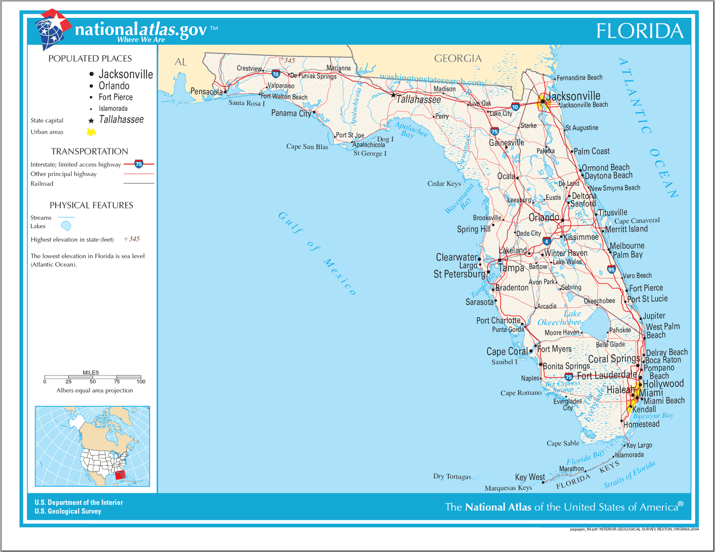
Florida State Map
Explore Florida with an interactive map featuring Street View, satellite and terrain views. Live weather, local news and location details for Florida — plus links to detailed street maps for 1,087 cities and towns across the state.
Map search is available for a limited number of queries per session to manage costs. Be specific — search precisely for best results.
| State | Florida |
| Capital | Tallahassee |
| Largest City | Jacksonville |
| Country | United States of America |
| Statehood | 1845 |
| Nickname | Sunshine State |
| Latitude | 28.1849 |
| Longitude | -82.16 |
| Population | 21,538,187 |
| Cities & Towns | 1,087 |
| Counties | 67 |
| County Map | Florida County Map |
About Florida
Florida unfolds as a long, low peninsula, a land shaped by the patient hand of water. Its terrain is remarkably flat, a gentle incline from the ancient Okefenokee Swamp in the north to the porous limestone bedrock that underpins much of its southern expanse. Rivers here are less forceful torrents and more languid arteries, such as the St. Johns, which flows north, an anomaly in its direction, and the Kissimmee, feeding the vast, shallow expanse of Lake Okeechobee. The coastline, a generous 1,350 miles, is a constant negotiation between land and sea, from the surf-battered Atlantic shores to the calmer, oyster-rich bays of the Gulf Coast. Distinct geological regions emerge: the Panhandle's piney woods and rolling hills, the central highlands dotted with ancient sand dunes, and the southern tip, where the unique sawgrass prairies of the Everglades meet the tangled roots of mangrove forests. The very air, thick with subtropical humidity, often carries the scent of salt and blooming jasmine, a fragrance that defines the state's pervasive atmosphere.
The human story of Florida began long before any European sail appeared on the horizon. Indigenous nations, such as the Calusa, Timucua, and Seminole, thrived for millennia, adapting to the varied environments from the coastal marshes to the inland forests. The arrival of Juan Ponce de León in 1513 marked the dawn of European contact, ushering in centuries of Spanish, then British, and finally American influence. Spanish colonial settlements, like St. Augustine, the oldest continuously inhabited European-established settlement in the United States, laid the foundations for a unique cultural blend. The territorial period, marked by conflict and growth, eventually led to Florida's statehood in 1845. The Civil War and Reconstruction left their indelible marks, but it was the post-Civil War era and the subsequent land booms of the late 19th and early 20th centuries that truly began to shape the Florida we recognize today, drawing people with promises of fertile land and a warmer clime, and transforming its wild beauty into a landscape of agriculture and burgeoning communities.
The economic engine of Florida has always been deeply connected to its natural bounty and its inviting climate. Historically, agriculture, particularly citrus cultivation, has been a cornerstone, with vast groves stretching across the central and southern parts of the state, producing oranges and grapefruits that grace tables far beyond its borders. Beyond citrus, the state’s fertile soil supports a diverse array of crops, from vegetables to sugarcane. However, Florida's economy has diversified considerably. Tourism, fueled by its miles of beaches, theme parks, and warm weather, is a dominant force, drawing millions of travelers annually. The aerospace industry has a significant presence, particularly in the central and eastern regions, and the state is a growing hub for technology and innovation. Fishing, both recreational and commercial, remains a vital part of coastal communities, reflecting the enduring relationship between the people and the abundant waters that surround Florida.
The cultural character of Florida is a vibrant, often surprising, mosaic. It is a place where the pace of life can shift dramatically from the languid drawl of a Panhandle fishing village to the bustling energy of a South Florida metropolis. The state is a magnet for diverse populations, drawing influence from the Caribbean, Latin America, and across the United States, creating a rich tapestry of languages, cuisines, and traditions. The distinctive sounds of Latin music mingle with country and blues in neighborhood bars, while the culinary scene offers everything from fresh seafood shacks to sophisticated international dining. Sports are deeply ingrained, with passionate followings for both collegiate and professional teams, from the roar of a football stadium to the cheers at a baseball game. The quality of light here, particularly at dusk when the sky ignites with fiery hues of orange and purple, seems to infuse the very air with a certain, almost tangible, magic, a subtle invitation to pause and observe the unfolding beauty of this unique American state.
Florida City and Town Maps
A
B
C
D
E
F
G
H
I
J
K
L
M
N
O
P
Q
R
S
T
V
W
Y
Florida Maps — Interactive Map, Street View, Weather & Local News
This page provides an interactive Google map of Florida (FL) with Street View, satellite and terrain views, alongside links to detailed street maps for 1,087 cities and towns across the state. The state capital is Tallahassee and the largest city is Jacksonville, with a state population of approximately 21,538,187.
Every city and town map page includes an embedded street and satellite map together with live weather. National Weather Service forecasts are combined with Open-Meteo graphical data including current conditions, an hourly outlook and a 7-day forecast. Local and world news feeds, Wikipedia location summaries and editorially written descriptions are included where available.
Location data is sourced from the USGS GNIS database and the SimpleMaps US Cities dataset, verified by coordinates rather than name matching alone.
