Maryland Map
Home Page > United States Map > Maryland Map
A large detailed map of Maryland
This is a large detailed map of Maryland.
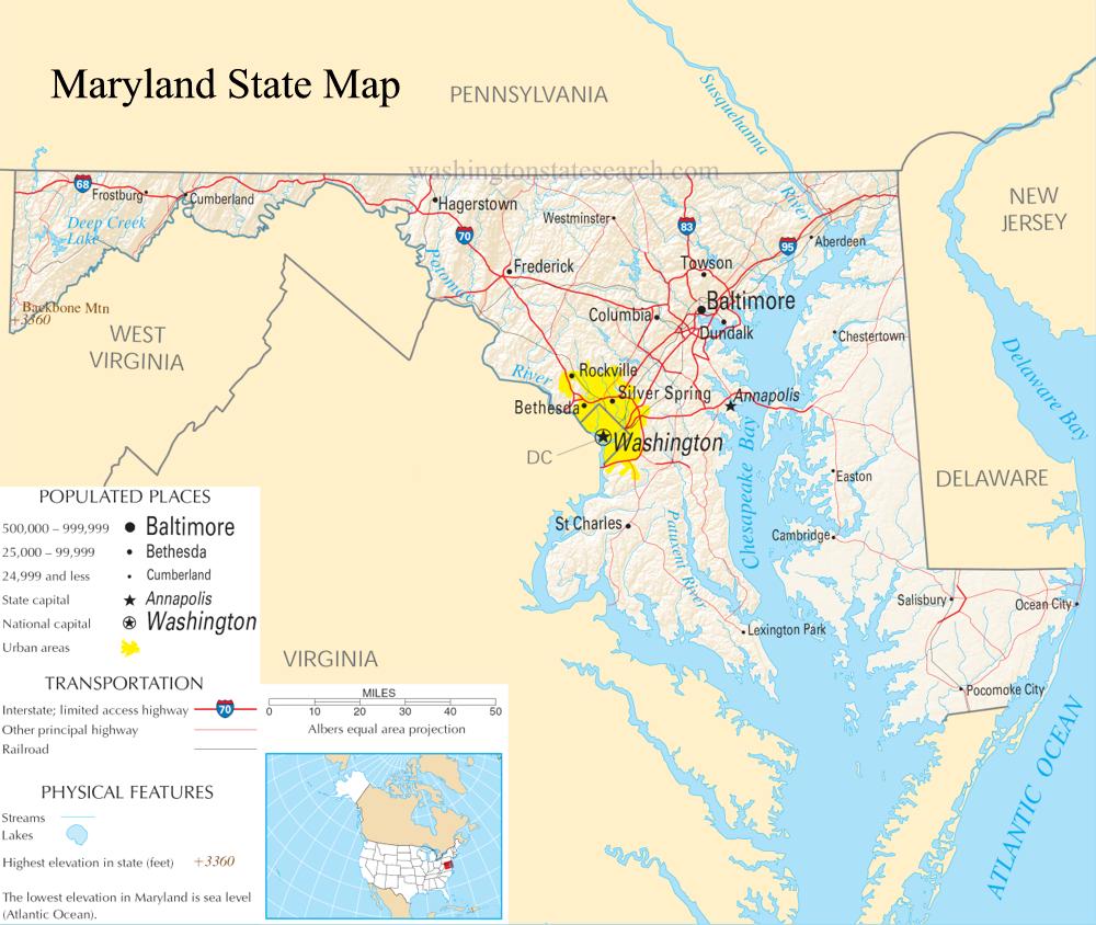
From the National Atlas of the United States
United States Department of the Interior.
Maryland State Map
The electronic map of Maryland State that is located below is provided by Google Maps. You can "grab" the Maryland State map and move it around to re-centre the map. You can change between standard map view and satellite map view by clicking the small square on the bottom left hand corner of the map. Satellite map view utilizes orbiting satellite or aerial high resolution photography to display images of the map location to street level detail (really quite amazing). Standard map view shows a traditional street map (also known as a road map). You can use the zoom buttons on the bottom right hand side of the map to zoom in or out to street level detail. We have maps for most towns and cities in the US, so click on the United States Maps link to see more American online maps.
Internal Page Shortcuts
A | B | C | D | E | F | G | H | I | J | K | L | M | N | O | P | Q | R | S | T | U | V | W | X | Y | Z
Abell | Aberdeen | Abingdon | Accident | Accokeek | Adamstown | Adelphi | Allegany | Allen | Annapolis | Annapolis Junction | Anne Arundel | Aquasco | Arbutus | Arnold | Ashton | Aspen Hill | Avenue
Bainbridge | Baldwin | Baltimore | Baltimore City | Barclay | Barnesville | Barstow | Barton | Beallsville | Bel Air | Bel Alton | Belcamp | Beltsville | Benedict | Berlin | Berwyn Heights | Bethesda | Bethlehem | Betterton | Big Pool | Bishopville | Bittinger | Bivalve | Bladensburg | Bloomington | Boonsboro | Bowie | Boyds | Bozman | Braddock Heights | Bradshaw | Brandywine | Brentwood | Brinklow | Brookeville | Brooklandville | Brooklyn | Brookview | Broomes Island | Brownsville | Brunswick | Bryans Road | Bryantown | Buckeystown | Burkittsville | Burtonsville | Bushwood | Butler
Cabin John | California | Callaway | Calvert | Calverton | Cambridge | Camp Springs | Cape Saint Claire | Capitol Heights | Cardiff | Caroline | Carroll | Cascade | Catonsville | Cavetown | Cecil | Cecilton | Centreville | Chaptico | Charles | Charlestown | Charlotte Hall | Chase | Cheltenham | Chesapeake Beach | Chesapeake City | Chester | Chestertown | Cheverly | Chevy Chase | Chewsville | Childs | Chillum | Church Creek | Church Hill | Churchton | Churchville | Claiborne | Clarksburg | Clarksville | Clear Spring | Clements | Clinton | Cobb Island | Cockeysville | Colesville | College Park | Colmar Manor | Colora | Coltons Point | Columbia | Conowingo | Cooksville | Cordova | Cottage City | Crellin | Cresaptown | Crisfield | Crocheron | Crofton | Croom | Crownsville | Crumpton | Cumberland | Curtis Bay
Damascus | Dameron | Dames Quarter | Darlington | Darnestown | Davidsonville | Dayton | Deal Island | Deale | Deer Park | Delmar | Denton | Derwood | Detour | Dickerson | District Heights | Dorchester | Doubs | Dowell | Drayden | Dundalk | Dunkirk
Earleville | East New Market | Easton | Eden | Edgemere | Edgewater | Edgewood | Eldersburg | Eldorado | Elk Mills | Elkridge | Elkton | Ellicott City | Emmitsburg | Emmorton | Essex | Eudowood | Ewell
Fair Hill | Fairmount Heights | Fairplay | Fallston | Faulkner | Federalsburg | Finksburg | Fishing Creek | Flintstone | Forest Glen | Forest Heights | Forest Hill | Forestville | Fork | Fort Detrick | Fort Howard | Fort Meade | Fort Washington | Frederick | Freeland | Friendly | Friendship | Friendship Heights | Friendsville | Frostburg | Fruitland | Fulton | Funkstown
Gaithersburg | Galena | Galestown | Galesville | Gambrills | Gapland | Garrett | Garrett Park | Georgetown | Germantown | Gibson Island | Girdletree | Glen Arm | Glen Burnie | Glen Echo | Glenarden | Glencoe | Glenelg | Glenn Dale | Glenwood | Glyndon | Goldsboro | Govans | Granite | Grantsville | Grasonville | Great Mills | Greenbelt | Greensboro | Gwynn Oak
Hagerstown | Halethorpe | Hampstead | Hancock | Hanover | Harford | Harford Heights | Harwood | Havre de Grace | Hebron | Helen | Henderson | Hereford | Highland | Highland Beach | Hillandale | Hillcrest Heights | Hillsboro | Hollywood | Howard | Hughesville | Hunt Valley | Huntingtown | Hurlock | Hyattstown | Hyattsville | Hydes
Ijamsville | Indian Head | Issue
Jacksonville | Jarrettsville | Jefferson | Jessup | Johnsville | Joppa
Keedysville | Kennedyville | Kensington | Kent | Keymar | Kingsville | Kitzmiller | Knoxville
La Plata | Landover | Landover Hills | Langley Park | Lanham | Lansdowne | Largo | Laurel | LaVale | Laytonsville | Leonardtown | Lewistown | Lexington Park | Libertytown | Lineboro | Linthicum | Linthicum Heights | Linwood | Lisbon | Little Orleans | Loch Lynn Heights | Loch Raven | Lonaconing | Long Green | Lothian | Loveville | Luke | Lusby | Lutherville
Manchester | Marbury | Mardela Springs | Marion | Marion Station | Marlow Heights | Marriottsville | Martin's Additions | Marydel | Maryland Line | Massey | Maugansville | Mayo | McCoole | McDaniel | McHenry | Mechanicsville | Middle River | Middletown | Midland | Millers | Millersville | Millington | Mitchellville | Monkton | Monrovia | Montgomery | Montgomery Village | Morganza | Morningside | Mount Airy | Mount Rainier | Mount Savage | Mount Washington | Mountain Lake Park | Myersville
Nanjemoy | Nanticoke | National Harbor | New Carrollton | New Market | New Midway | New Windsor | Newark | Newburg | North Beach | North Bethesda | North Brentwood | North East | North Potomac | Nottingham
Oakland | Ocean City | Ocean Pines | Odenton | Oldtown | Olney | Owings | Owings Mills | Oxford | Oxon Hill
Park Hall | Parkton | Parkville | Parsonsburg | Pasadena | Patuxent River | Perry Hall | Perry Point | Perryman | Perryville | Petersville | Phoenix | Pikesville | Piney Point | Pisgah | Pittsville | Pocomoke City | Point of Rocks | Pomfret | Poolesville | Poplar Springs | Port Deposit | Port Republic | Port Tobacco | Potomac | Powellville | Preston | Prince Frederick | Prince George's | Princess Anne | Pylesville
Quantico | Queen Anne | Queen Anne's | Queenstown
Randallstown | Rawlings | Reisterstown | Relay | Rhodesdale | Riderwood | Ridge | Ridgely | Rising Sun | Riva | Riverdale | Riverdale Park | Riviera Beach | Rock Hall | Rock Point | Rockville | Rocky Ridge | Rohrersville | Rose Haven | Rosedale | Rosemont | Royal Oak | Ruxton
Sabillasville | Saint Charles | Saint Inigoes | Saint Leonard | Saint Mary's | Saint Mary's City | Saint Michaels | Salisbury | Sandy Spring | Savage | Scotland | Seabrook | Seat Pleasant | Secretary | Severn | Severna Park | Shady Side | Sharpsburg | Sharptown | Sherwood | Sherwood Forest | Showell | Silver Spring | Smithsburg | Snow Hill | Solomons | Somerset | Sparks | Sparrows Point | Spencerville | Springdale | Stevenson | Stevensville | Still Pond | Stockton | Street | Sudlersville | Suitland | Sunderland | Swan Point | Swanton | Sykesville
Takoma Park | Talbot | Tall Timbers | Taneytown | Temple Hills | Templeville | Thurmont | Tilghman Island | Timonium | Towson | Tracys Landing | Trappe | Tuscarora | Tyaskin | Tylerton
Union Bridge | University Park | Upper Fairmount | Upper Falls | Upper Marlboro | Upperco | Urbana
Waldorf | Walkersville | Warwick | Washington | Washington Grove | Welcome | Wenona | West Bethesda | West Friendship | West Ocean City | West River | Westernport | Westminster | Westover | Whaleyville | Wheaton | White Hall | White Marsh | White Plains | Whiteford | Whitehaven | Wicomico | Willards | Williamsport | Windsor Mill | Wittman | Woodbine | Woodlawn | Woodsboro | Woodstock | Woolford | Worcester | Worton | Wye Mills
Maryland State Map
Go to our Large Maryland State Map