Kentucky State Map
Home Page > United States Map > Kentucky State Map
About Kentucky State
Kentucky is a state located in the mid-eastern region of the United States. Here are some key aspects about the state:
Capital and Major Cities
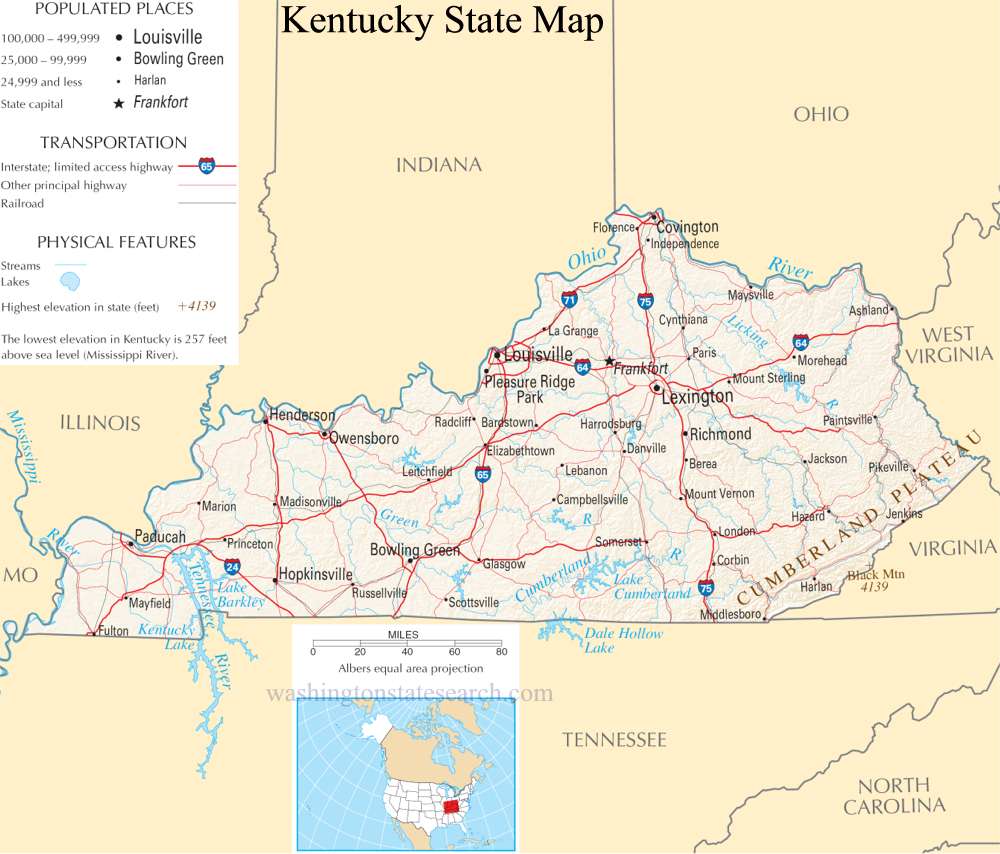
- Capital: Frankfort
- Largest City: Louisville
Geography
- Kentucky is known for its diverse geography, which includes the Appalachian Mountains in the east, the rolling hills in the central region, and the Bluegrass Region in the north-central part of the state.
- The Ohio River forms much of Kentucky's northern border.
Economy
- Historically, Kentucky's economy has been tied to agriculture, particularly horse breeding and tobacco farming. The state is famous for its thoroughbred horse industry, and the Kentucky Derby, held annually in Louisville, is one of the most prestigious horse races in the world.
- Over the years, Kentucky has diversified its economy, with manufacturing, healthcare, and service industries playing important roles.
Culture and Traditions
- Kentucky is often associated with bluegrass music and is considered the birthplace of this genre. The state has a rich cultural heritage, and events such as the Kentucky Derby and the Kentucky Bourbon Festival are celebrated annually.
- Bourbon whiskey is a significant part of Kentucky's cultural identity, and the state is home to numerous distilleries.
Education
- The state is home to several notable universities, including the University of Kentucky and the University of Louisville.
Natural Attractions
- Mammoth Cave National Park, located in south-central Kentucky, is home to the world's longest-known cave system.
- The Red River Gorge, located in the Daniel Boone National Forest, is a popular destination for outdoor enthusiasts.
Historical Significance
- Kentucky played a crucial role in the American Civil War. The state was a border state, and its strategic location made it a contested area during the conflict.
Population and Demographics
- Kentucky has a diverse population, with a mix of urban and rural areas. The state has historically had ties to both Southern and Midwestern cultures.
A large detailed map of Kentucky State
This is a large detailed map of Kentucky State.
View our Kentucky State county map
from the National Atlas of the United States
United States Department of the Interior
Kentucky State Map
The electronic map of Kentucky State that is located below is provided by Google Maps. You can "grab" the Kentucky State map and move it around to re-centre the map. You can change between standard map view and satellite map view by clicking the small square on the bottom left hand corner of the map. Satellite map view utilizes orbiting satellite or aerial high resolution photography to display images of the map location to street level detail (really quite amazing). Standard map view shows a traditional street map (also known as a road map). You can use the zoom buttons on the bottom right hand side of the map to zoom in or out to street level detail. We have maps for most towns and cities in the US, so click on the United States Maps link to see more American online maps.