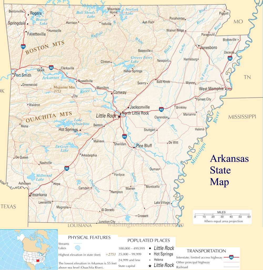
Arkansas State Map
Home Page > United States Map > Arkansas State Map
About Arkansas State
Arkansas is a state located in the southern region of the United States, known for its natural beauty, diverse geography, and rich history. Here are some key aspects of the State of Arkansas:
Geography
Arkansas is situated in the southeastern part of the United States and is characterized by a diverse landscape. The state features mountains, such as the Ozarks and the Ouachitas, as well as fertile plains and river valleys. The Mississippi River forms Arkansas's eastern border, and the state is often referred to as the "Natural State" due to its abundant natural resources.
Capital
The capital of Arkansas is Little Rock, which is also the state's largest city. Little Rock is the political, economic, and cultural center of the state.
Natural Beauty
Arkansas is renowned for its natural beauty, with numerous state parks, forests, and outdoor recreational opportunities. The Ozark Mountains in the northwestern part of the state are a popular destination for hiking, camping, and scenic drives. The Buffalo National River, the first designated national river in the United States, offers excellent opportunities for canoeing and kayaking.
Economy
Arkansas's economy is diverse, with key sectors including agriculture, manufacturing, transportation, and retail. The state is a major producer of poultry, rice, cotton, and soybeans. Major corporations such as Walmart, Tyson Foods, and J.B. Hunt Transport Services have their headquarters in Arkansas.
Culture
Arkansas has a rich cultural heritage that includes a blend of Native American, African American, and European influences. The state's music and arts scene features various genres, including bluegrass, country, and the blues. The Johnny Cash Museum in Dyess is a tribute to the legendary musician who was born in Arkansas.
Education
Arkansas is home to several higher education institutions, including the University of Arkansas, Arkansas State University, and the University of Central Arkansas. These universities contribute to the state's educational and research community.
Civil Rights History
Little Rock played a significant role in the civil rights movement. The Little Rock Central High School desegregation crisis in 1957 was a pivotal moment in the struggle for civil rights in the United States. The Central High School National Historic Site commemorates this history.
Cultural Attractions
Arkansas offers cultural attractions such as the Crystal Bridges Museum of American Art in Bentonville, which features a diverse collection of American artwork. The Clinton Presidential Center and Park in Little Rock showcases the life and legacy of former U.S. President Bill Clinton.
Outdoor Activities
The state provides ample opportunities for outdoor activities, including hunting, fishing, boating, and birdwatching. The state's many lakes, rivers, and parks make it a popular destination for outdoor enthusiasts.
Challenges
Arkansas faces challenges such as educational disparities, particularly in rural areas, and healthcare access for its residents. Like many other states, it grapples with issues related to economic development, education, and healthcare.
In summary, Arkansas is a state with a rich cultural heritage, natural beauty, and a diverse economy. Its blend of history, arts, and outdoor recreational opportunities makes it an intriguing part of the United States.
A large detailed map of Arkansas State
This is a large detailed map of Arkansas State.
View our Arkansas State county map
from the National Atlas of the United States
United States Department of the Interior
Arkansas State Map
The electronic map of Arkansas State that is located below is provided by Google Maps. You can "grab" the Arkansas State map and move it around to re-centre the map. You can change between standard map view and satellite map view by clicking the small square on the bottom left hand corner of the map. Satellite map view utilizes orbiting satellite or aerial high resolution photography to display images of the map location to street level detail (really quite amazing). Standard map view shows a traditional street map (also known as a road map). You can use the zoom buttons on the bottom right hand side of the map to zoom in or out to street level detail. We have maps for most towns and cities in the US, so click on the United States Maps link to see more American online maps.