Australian Capital Territory Road Network Maps
Enter your search query in the box below.
Home > Australian Maps > Australian Capital Territory Road Maps
Welcome to our Australian Capital Territory road map page. The map of the Australian Capital Territory that is located below is provided by Google Maps. You can "grab" the Australian Capital
Territory road map and move it around to re-centre the map. You can change between standard map view
and satellite map view. You can also use the zoom bar to zoom in or out. You can use the search form
above the map to search for any location on.
I hope you like the Australian Capital Territory, ACT, AU street map / road map situated above.
If you like our website, please consider adding a link to the site. These links help to build website traffic and they are considered a vote of confidence for a site.
City Maps
Adelaide Map |
Brisbane Map |
Cairns Map |
Canberra Map |
Darwin Map |
Hobart Map |
Melbourne Map |
Perth Map |
Sydney Map
State Maps
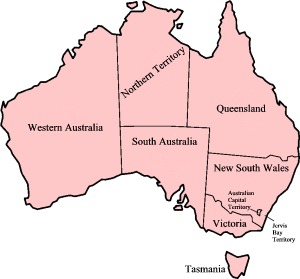
Australian Capital Territory |
New South Wales |
Northern Territory |
Queensland |
South Australia |
Tasmania |
Victoria |
Western Australia
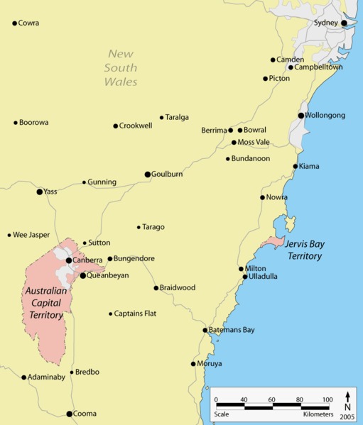
Australian Capital Territory ACT Map
From Wikipedia, the free encyclopaedia
Maps of Australian Capital Territory (ACT)
A |
B |
C |
D |
E |
F |
G |
H |
I |
J |
K |
L |
M |
N |
O |
P |
Q |
R |
S |
T |
U |
V |
W |
X |
Y |
Z
Acton |
Ainslie |
Amaroo |
Aranda
Banks |
Barton |
Belconnen |
Bimberi |
Bonner |
Bonython |
Booth |
Braddon |
Brindabella |
Bruce
Calwell |
Campbell |
Canberra |
Canberra CBD |
Canberra International Airport |
Capital Hill |
Casey |
Chapman |
Charnwood |
Chifley |
Chisholm |
Conder |
Cook |
Coree |
Cotter River |
Crace |
Curtin
Deakin |
Dickson |
Downer |
Duffy |
Dunlop
Erindale |
Evatt
Fadden |
Farrer |
Fisher |
Florey |
Flynn |
Forde |
Forrest |
Franklin |
Fraser |
Fyshwick
Garran |
Gilmore |
Giralang |
Gordon |
Gowrie |
Greenway |
Griffith |
Gungahlin
Hackett |
Hall |
Harman |
Harrison |
Hawker |
Higgins |
Holder |
Holt |
Hughes |
Hume
Isaacs |
Isabella Plains
Jacka |
Jamison Centre
Kaleen |
Kambah |
Kenny |
Kingston |
Kinlyside |
Kippax |
Kowen |
Kowen Pine Forest
Latham |
Lawson |
Lyneham |
Lyons
Macarthur |
Macgregor |
Macquarie |
Majura |
Manuka |
Mawson |
Mckellar |
Melba |
Mitchell |
Monash |
Moncrieff |
Mount Clear |
Mt Clear
Narrabundah |
Ngunnawal |
Nicholls
Oaks Estate |
O'connor |
O'malley |
Oxley
Paddys River |
Page |
Palmerston |
Parkes |
Pearce |
Phillip |
Pialligo
Red Hill |
Reid |
Rendezvous Creek |
Richardson |
Rivett |
Russell
Scullin |
Spence |
Stirling |
Stromlo |
Symonston
Taylor |
Tennent |
Tharwa |
Theodore |
Throsby |
Torrens |
Tuggeranong |
Turner
Uriarra
Wanniassa |
Waramanga |
Watson |
Weetangera |
Weston |
Weston Creek |
Woden |
Woden Valley
Yarralumla
Map of Australian States and Territories
Music