New South Wales Australia Road Network Maps
Home > Australian Maps > New South Wales Maps
Welcome to our New South Wales Australia road map page. The map of New South Wales Australia that is located below is provided by Google Maps. You can "grab" the New South Wales Australia road map and move it around to re-centre the map. You can change between standard map view and satellite map view using the small square on the bottom left hand corner of the map. Satellite map view utilizes orbiting satellite or aerial high resolution photography to display images of the map location to street level detail (really quite amazing). Standard map view shows a traditional street map sometimes called a road map. You can use the zoom buttons on the bottom right hand side of the map to zoom in or out to street level detail. We have maps for most Australian towns and cities, so click on the Australian Maps link to see more Australian maps.
I hope you like the New South Wales, NSW, AU street map / road map situated above.
If you like our website, please consider adding a link to the site. These links help to build website traffic and they are considered a vote of confidence for a site.
A Map of The State of New South Wales, Australia
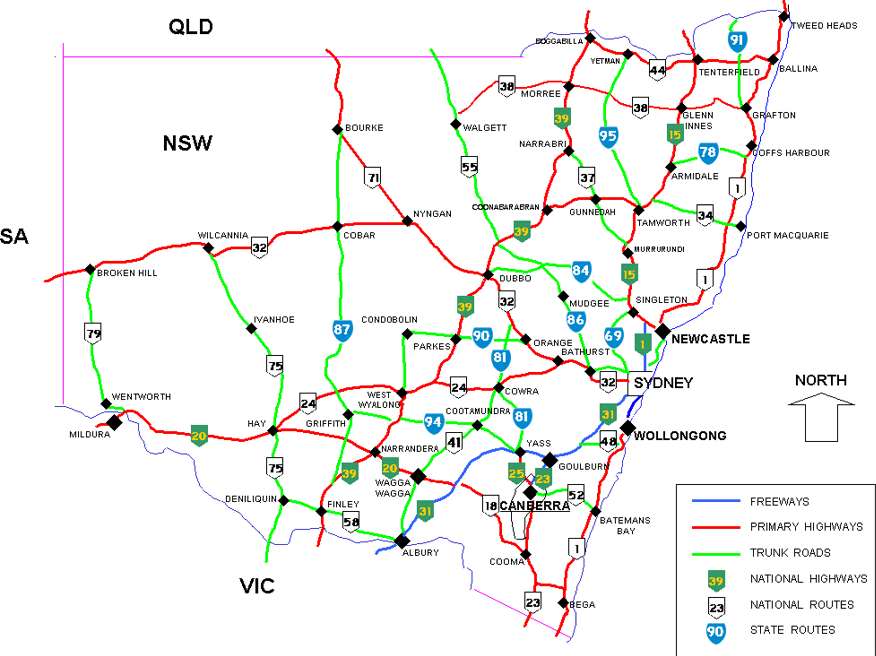
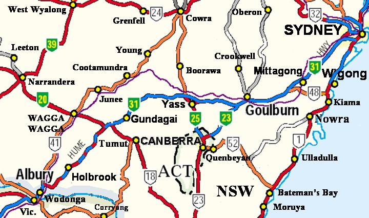
A road map of the State of New South Wales, Australia. Find the best route between Canberra, Newcastle, Sydney and Wollongong. Locations on this map of New South Wales include Albury-Wodonga, Armidale, Bathurst, Broken Hill, Cessnock, Coffs Harbour, Bourke, Dubbo, Gosford, Goulburn, Grafton, Lake Macquarie, Lismore, Maitland, Newcastle, Nowra, Orange, Port Macquarie, Sydney, Tamworth, Tweed Heads, Wagga Wagga, Wollongong.
From Wikipedia, the free encyclopaedia
Hume Highway - NSW
Canberra can be accessed by the Hume Highway with connections at Federal Highway (green National Highway 23) and Barton Highway (National Highway 25). It can also be accessed from the south by the Monaro Highway (white National Highway 23
From Wikipedia, the free encyclopedia
Maps of New South Wales Australia
A | B | C | D | E | F | G | H | I | J | K | L | M | N | O | P | Q | R | S | T | U | V | W | X | Y | Z
A
Abbotsbury | Abbotsford | Aberdeen | Abermain | Adaminaby | Adamstown | Adelong | Albion Park | Albury | Alexandria | Alfords Point | Allambie Heights | Allawah | Alstonville | Ambarvale | Angourie | Anna Bay | Annandale | Annangrove | Appin | Arcadia | Armidale | Arncliffe | Arndell Park | Arrawarra | Artarmon | Ashbury | Ashcroft | Ashfield | Ashford | Asquith | Auburn | Austinmer | Austral | Avalon | Avoca Beach
B
Balgowlah | Balgownie | Ballina | Balmain | Balranald | Bangalow | Bangor | Banksmeadow | Bankstown | Banora Point | Bardwell Park | Bargo | Barham | Barkers Vale | Barnsley | Barooga | Barraba | Barrington | Bateau Bay | Batehaven | Batemans Bay | Bathurst | Batlow | Baulkham Hills | Bawley Point | Bayview | Beacon Hill | Beaconsfield | Beecroft | Bega | Belford | Bella Vista | Bellambi | Bellevue Hill | Bellingen | Belmont | Belmore | Belrose | Ben Lomond | Bendalong | Bennetts Green | Berala | Beresfield | Berkeley | Berkeley Vale | Berkshire Park | Bermagui | Berowra | Berowra Heights | Berowra Waters | Berridale | Berrima | Berry | Beverly Hills | Bexley | Bexley North | Bigga | Bilambil | Bilgola | Billinudgel | Bilpin | Binda | Bingara | Bingie | Birchgrove | Birmingham Gardens | Birrong | Blackheath | Blacktown | Blakehurst | Blaxland | Blayney | Blue Bay | Bluehaven | Boambee | Bodalla | Bolton Point | Bomaderry | Bombala | Bonalbo | Bondi | Bondi Beach | Bondi Junction | Bonnells Bay | Bonnet Bay | Bonny Hills | Bonnyrigg | Bonville | Boolaroo | Boorowa | Borenore | Bossley Park | Botany | Bourke | Bowral | Bowraville | Box Hill | Braidwood | Branxton | Brayton | Bredbo | Brighton-Le-Sands | Brindabella | Broadmeadow | Brogo | Broke | Broken Head | Broken Hill | Bronte | Brooklyn | Brookvale | Broulee | Brunswick Heads | Bucketty | Budgewoi | Bulahdelah | Bullaburra | Bulli | Bundanoon | Bundeena | Bungendore | Burradoo | Burrawang | Burrill Lake | Burwood | Buxton | Byron Bay
C
Cabarita | Cabramatta | Callala Bay | Callala Beach | Cambewarra | Camden | Cammeray | Campbelltown | Camperdown | Campsie | Cams Wharf | Candelo | Canley Vale | Canowindra | Canterbury | Captains Flat | Carcoar | Cardiff | Caringbah | Carlingford | Carlton | Carool | Carramar | Casino | Castle Cove | Castle Hill | Castlecrag | Casula | Catalina | Catherine Field | Cattai | Cecil Park | Centennial Park | Central Tilba | Cessnock | Chain Valley Bay | Charlestown | Charmhaven | Chatswood | Cheltenham | Cherrybrook | Chester Hill | Chifley | Chinderah | Chippendale | Chipping Norton | Chittaway Bay | Chullora | Church Point | Clarendon | Clareville | Clontarf | Clovelly | Clunes | Cobar | Cobargo | Cobbitty | Coffs Harbour | Coila | Coledale | Collaroy | Collaroy Plateau | Colo | Colo Vale | Como | Conargo | Concord | Condell Park | Condobolin | Coniston | Connells Point | Coogee | Cooks Hill | Coolah | Cooma | Coonabarabran | Coonamble | Coorabel | Cooranbong | Cootamundra | Coraki | Corindi Beach | Corlette | Corowa | Corrimal | Cougal | Coutts Crossing | Cowan | Cowper | Cowra | Cranebrook | Cremorne | Crescent Head | Cromer | Cronulla | Crookwell | Crows Nest | Croydon | Crystal Creek | Cudal | Culburra Beach | Culcairn | Cullendulla | Curl Curl | Currabubula | Currarong
D
Daceyville | Dairyville | Dalgety | Dalmeny | Dalton | Dalwood | Dapto | Darling Point | Darlinghurst | Darlington | Darlington Point | Davidson | Davistown | Dawes Point | Dee Why | Deepwater | Deervale | Deniliquin | Denistone | Denman | Depot Beach | Dharruk | Dolls Point | Doonside | Dooralong | Dorrigo | Double Bay | Douglas Park | Dover Heights | Doyalson | Drummoyne | Dubbo | Dudley | Duffys Forest | Dulwich Hill | Dundas | Dunedoo | Dungog | Dural | Durras
E
Earlwood | East Hills | Eastern Creek | Eastlakes | Eastwood | Ebenezer | Ebor | Eden | Edgecliff | Edgeworth | Eglinton | Elanora Heights | Elizabeth Bay | Ellangowan | Ellenborough | Emerald Beach | Emmaville | Empire Bay | Empire Vale | Emu Heights | Emu Plains | Enfield | Engadine | Enmore | Epping | Erina | Erina Heights | Ermington | Erowal Bay | Erskine Park | Erskineville | Eschol Park | Ettalong Beach | Ettrick | Evans Head | Eveleigh | Exeter
F
Fairfield | Fairlight | Fairy Meadow | Falls Creek | Fassifern | Faulconbridge | Figtree | Finley | Firefly | Five Dock | Flemington | Flinders | Forbes | Fordwich | Forest Lodge | Forestville | Forresters Beach | Forster | Freemans Reach | Frenchs Forest
G
Galston | Ganmain | Gateshead | Geneva | Georges Hall | Gerringong | Gilgandra | Girraween | Gladesville | Glebe | Glen Innes | Glen William | Glenbrook | Glencoe | Glendale | Glendenning | Glenhaven | Gleniffer | Glenmore Park | Glenorie | Glenreagh | Glenwood | Glossodia | Gloucester | Goonellabah | Gordon | Gorokan | Gosford | Goulburn | Grafton | Granville | Grays Point | Green Point | Green Valley | Greenacre | Greenwell Point | Greenwich | Grenfell | Gresford | Greta | Greystanes | Griffith | Grose Vale | Guildford | Gulgong | Gundagai | Gunnedah | Gunning | Guyra | Gwandalan | Gymea
H
Haberfield | Halfway Creek | Hallidays Point | Hamilton | Hammondville | Hampton | Hannam Vale | Harbord | Hardys Bay | Harrington | Harris Park | Hartley | Hastings Point | Hat Head | Hawks Nest | Hay | Haymarket | Hazelbrook | Heathcote | Heatherbrae | Helensburgh | Henty | Herons Creek | Hexham | High Range | Hillgrove | Hillsdale | Hinchinbrook | Holbrook | Holroyd | Holsworthy | Homebush | Homebush Bay | Homebush West | Hornsby | Hornsby Heights | Horsley Park | Howlong | Hoxton Park | Hungry Head | Hunters Hill | Hurlstone Park | Hurstville | Huskisson | Hyams Beach | Hyland Park
I
Illawong | Iluka | Ingleburn | Ingleside | Inverell | Islington
J
Jamberoo | Jamisontown | Jannali | Jaspers Brush | Jenolan Caves | Jerilderie | Jerrabomberra | Jesmond | Jilliby | Jindabyne | Johns River | Junee
K
Kalaru | Kanahooka | Kangaroo Valley | Karangi | Kareela | Kariong | Katoomba | Kearsley | Keiraville | Kellyville | Kelso | Kemps Creek | Kempsey | Kensington | Kenthurst | Kentlyn | Kentucky | Kew | Khancoban | Kiah | Kiama | Kianga | Kilaben Bay | Killara | Killarney Heights | Killarney Vale | Killcare | Killcare Heights | Killingworth | Kincumber | Kings Langley | Kings Park | Kingscliff | Kingsford | Kingsgrove | Kingswood | Kioloa | Kirrawee | Kirribilli | Kogarah | Koonawarra | Kootingal | Korora Bay | Kotara | Kulnura | Kurmond | Kurnell | Kurrajong | Kurrajong Heights | Kurri Kurri | Kyeemagh | Kyogle
L
La Perouse | Laguna | Lake Cargelligo | Lake Cathie | Lake Conjola | Lake Haven | Lake Munmorah | Lake Tabourie | Lakemba | Lalor Park | Lambton | Lane Cove | Lansvale | Laurieton | Lavington | Lawson | Leeton | Leichhardt | Lemon Tree Passage | Lennox Head | Leonay | Leppington | Leumeah | Leura | Lewisham | Lidcombe | Lightning Ridge | Lilli Pilli Batemans Bay | Lilli Pilli Sydney | Lilyfield | Limeburners Creek | Lindfield | Lisarow | Lismore | Lithgow | Little Bay | Liverpool | Llandilo | Lockhart | Loftus | Londonderry | Long Beach | Long Jetty | Long Point | Longueville | Lorne | Louth | Lovedale | Lower Belford | Lower Mangrove | Lower Portland | Lucas Heights | Luddenham | Lugarno | Lurnea
M
Macksville | Maclean | MacMasters Beach | Macquarie Fields | Macquarie Park | Maitland | Malabar | Mallan | Malua Bay | Mandalong | Mangrove Mountain | Manildra | Manilla | Manly | Manly Vale | Mannering Park | Mannus | Manyana | Marayong | Marks Point | Maroubra | Marrickville | Marsfield | Martinsville | Maryland | Mascot | Matraville | Mayfield | McGraths Hill | McMahons Point | Meadowbank | Medlow Bath | Medowie | Meerschaum Vale | Megalong | Menai | Menangle | Merewether | Merimbula | Merriwa | Merrylands | Millers Point | Millfield | Milperra | Milsons Point | Milton | Minchinbury | Minnamurra | Minto | Miranda | Mittagong | Moama | Mogo | Mollymook | Molong | Mona Vale | Monterey | Mooney Mooney | Moore Park | Moorebank | Morans Crossing | Moree | Morisset | Morisset Park | Morpeth | Mortdale | Mortlake | Moruya | Mosman | Moss Vale | Mount Annan | Mount Colah | Mount Druitt | Mount Hope | Mount Keira | Mount Kuring-gai | Mount Lewis | Mount Pleasant | Mount Pritchard | Mount Victoria | Mount View | Mount Vincent | Mudgee | Mulbring | Mulgoa | Mulgrave | Mullengandra | Mullumbimby | Mungindi | Murrumbateman | Murrurundi | Murwillumbah | Muswellbrook | Mylestom | Myola | Mystery Bay
N
Nabiac | Nambucca Heads | Narara | Narellan | Narooma | Narrabeen | Narrabri | Narrandera | Narrawallee | Narraweena | Narromine | Narwee | Nelligen | Nelson Bay | Nerriga | Neutral Bay | New Brighton | New Lambton | Newcastle | Newington | Newport | Newrybar | Newtown | Niagara Park | Nimbin | Nimmitabel | Normanhurst | North Durras | North Haven | North Manly | North Narrabeen | North Rocks | North Rothbury | North Ryde | North Strathfield | North Sydney | North Turramurra | Northbridge | Northmead | Northwood | Nowra | Nundle | Nymboida | Nyngan
O
Oak Flats | Oatlands | Oatley | Oberon | OConnell | Old Bar | One Mile Beach | Oran Park | Orange | Orchard Hills | Ourimbah | Oxford Falls | Oyster Bay
P
Pacific Palms | Paddington | Padstow | Pagewood | Palm Beach | Palmdale | Pambula | Panania | Parkes | Parklea | Parramatta | Paterson | Peakhurst | Pearl Beach | Peats Ridge | Pelican | Pendle Hill | Pennant Hills | Penrith | Penshurst | Perisher | Petersham | Picton | Pindimar | Pitt Town | Plumpton | Point Piper | Pokolbin | Port Hacking | Port Kembla | Port Macquarie | Portland | Potato Point | Potts Point | Pottsville | Prestons | Prospect | Punchbowl | Putney | Pymble | Pyrmont
Q
Quaama | Quakers Hill | Quambone | Queanbeyan | Queenscliff | Quirindi
R
Raby | Raleigh | Ramsgate | Randwick | Rathmines | Raymond Terrace | Redfern | Redhead | Regents Park | Revesby | Rhodes | Richmond | Riverstone | Riverview | Riverwood | Robertson | Rockdale | Rodd Point | Rooty Hill | Rose Bay | Rosebery | Rosehill | Roselands | Rosemeadow | Roseville | Rothbury | Rouse Hill | Rozelle | Rushcutters Bay | Russell Vale | Rydalmere | Ryde
S
Salamander Bay | Salt Ash | Sanctuary Point | Sandgate | Sans Souci | Sapphire Beach | Saratoga | Sawtell | Scone | Scotts Head | Seaforth | Sefton | Seven Hills | Shell Cove | Shellharbour | Shelly Beach | Shoal Bay | Shoalhaven Heads | Shortland | Silverwater | Singleton | Smithfield | Smiths Lake | Soldiers Point | Somersby | South Durras | South Granville | South Nowra | South Penrith | South West Rocks | South Windsor | Speers Point | Spencer | Springwood | St Albans | St Clair | St Georges Basin | St Ives | St Johns Park | St Leonards | St Marys | St Peters | Stanhope Gardens | Stanmore | Stanwell Park | Strathfield | Strathfield South | Stuart Town | Summer Hill | Summerland Point | Sunshine Bay | Surf Beach | Surry Hills | Sussex Inlet | Sutherland | Sutton | Sutton Forest | Swansea | Sydenham | Sydney CBD | Sylvania | Sylvania Waters
T
Tacoma | Talarm | Tamarama | Tamworth | Tanilba Bay | Taralga | Tarana | Taree | Taren Point | Tarrawanna | Tathra | Taylors Beach | Tea Gardens | Telarah | Telopea | Temora | Tempe | Tenambit | Tenterfield | Teralba | Termeil | Terrey Hills | Terrigal | The Entrance | The Junction | The Oaks | The Rocks | Theresa Park | Thirlmere | Thirroul | Thornleigh | Thornton | Thredbo | Tilba Tilba | Tingha | Tingira Heights | Tinonee | Tintenbar | Tirrannaville | Tocumwal | Tomago | Tomakin | Toongabbie | Toormina | Toronto | Toukley | Tregeagle | Tregear | Tucabia | Tuggerah | Tuggerawong | Tullamore | Tumbarumba | Tumbi Umbi | Tumbulgum | Tumut | Tuncurry | Tuross Head | Turramurra | Turrella | Tweed Heads | Tyagarah | Tyndale
U
Ulladulla | Ulmarra | Ultimo | Umina | Unanderra | Upper Orara | Uralla | Urunga
V
Valentine | Valla Beach | Valley Heights | Vaucluse | Villawood | Vincentia | Vineyard
W
Wadeville | Wagga Wagga | Wahroonga | Waitara | Wakeley | Walcha | Walgett | Wallabi Point | Wallacia | Wallerawang | Wallsend | Wamberal | Wandandian | Wangi Wangi | Warabrook | Waratah | Wardell | Wards River | Wareemba | Warialda | Warners Bay | Warnervale | Warragamba | Warrawee | Warrawong | Warren | Warriewood | Warringah | Warwick Farm | Waterfall | Waterloo | Watsons Bay | Wattle Grove | Wauchope | Waverley | Waverton | Wee Jasper | Wee Waa | Wellington | Wentworth | Wentworth Falls | Wentworthville | Werrington | Werris Creek | West Pennant Hills | West Ryde | Westleigh | Westmead | Wetherill Park | Wickham | Wilberforce | Wilcannia | Wiley Park | Williamtown | Willoughby | Willow Tree | Windang | Windsor | Wingello | Wingham | Winmalee | Winston Hills | Wisemans Ferry | Wollemi | Wolli Creek | Wollombi | Wollongbar | Wollongong | Wollstonecraft | Woodenbong | Woodford | Woolgoolga | Wooli | Woollahra | Woollamia | Woolloomooloo | Woolooware | Woolwich | Woronora | Worrigee | Woy Woy | Wyee | Wyndham | Wyoming | Wyong | Wyongah
Y
Yagoona | Yamba | Yarrahapinni | Yarramalong | Yarrawarrah | Yass | Yenda | Yennora | Yetholme | Young | Yowie Bay
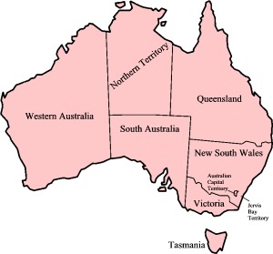
Map of Australian States and Territories