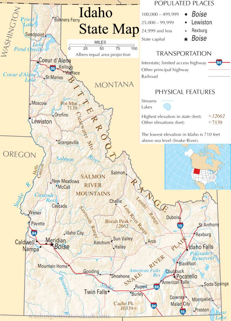
Idaho State Map
Home Page > United States Map > Idaho State Map
About Idaho State
Idaho is a state located in the northwestern region of the United States. It is known for its diverse geography, including mountains, forests, and agricultural plains. Here are some key points about the state:
Capital and Major Cities
- Capital: Boise
- Major Cities: Other significant cities in Idaho include Nampa, Meridian, Idaho Falls, Pocatello, and Twin Falls.
Geography
- Idaho is characterized by its varied landscape, which includes mountain ranges, plateaus, forests, and rivers.
- The Rocky Mountains cover much of the state, and the northern part of Idaho is home to the Selkirk, Cabinet, and Bitterroot mountain ranges.
- The Snake River is a major waterway that flows through the state and has carved out the deep Hells Canyon, the deepest river gorge in North America.
Economy
- Idaho's economy is diverse, with agriculture, manufacturing, technology, and outdoor recreation playing significant roles.
- Agriculture is a major contributor, and Idaho is known for its production of potatoes, which are a staple crop. The state also produces a variety of other crops, including wheat, barley, sugar beets, and dairy products.
- The technology sector has grown in recent years, particularly in the Boise area, attracting companies in software development and other high-tech industries.
Outdoor Recreation
- Idaho is a haven for outdoor enthusiasts, offering opportunities for activities such as hiking, skiing, fishing, rafting, and camping.
- Sun Valley, in central Idaho, is a renowned destination for winter sports, including skiing and snowboarding.
National Parks and Forests
- Idaho is home to several national parks and forests, including Yellowstone National Park (which extends into Idaho), Craters of the Moon National Monument and Preserve, Sawtooth National Recreation Area, and the Frank Church-River of No Return Wilderness.
Culture and Demographics
- The state has a relatively small population compared to its land area.
- Idaho has a mix of urban and rural communities, and its cultural influences come from Native American, European, and more recent migration patterns.
- The state is known for its friendly communities and a strong sense of community.
History
- Idaho's history includes a significant Native American presence, exploration by Lewis and Clark in the early 19th century, and the influx of settlers during the Gold Rush era in the mid-1800s.
- Idaho became a state on July 3, 1890, making it the 43rd state in the United States.
Idaho's combination of natural beauty, outdoor recreational opportunities, and a growing economy makes it a unique and appealing state with a variety of attractions for residents and visitors alike.
A large detailed map of Idaho State
This is a large detailed map of Idaho State.
View our Idaho State county map
from the National Atlas of the United States
United States Department of the Interior
Idaho State Map
The electronic map of Idaho State that is located below is provided by Google Maps. You can "grab" the Idaho State map and move it around to re-centre the map. You can change between standard map view and satellite map view by clicking the small square on the bottom left hand corner of the map. Satellite map view utilizes orbiting satellite or aerial high resolution photography to display images of the map location to street level detail (really quite amazing). Standard map view shows a traditional street map (also known as a road map). You can use the zoom buttons on the bottom right hand side of the map to zoom in or out to street level detail. We have maps for most towns and cities in the US, so click on the United States Maps link to see more American online maps.