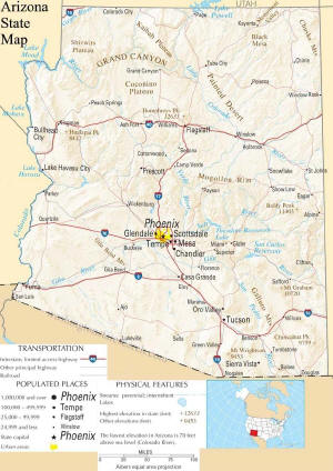
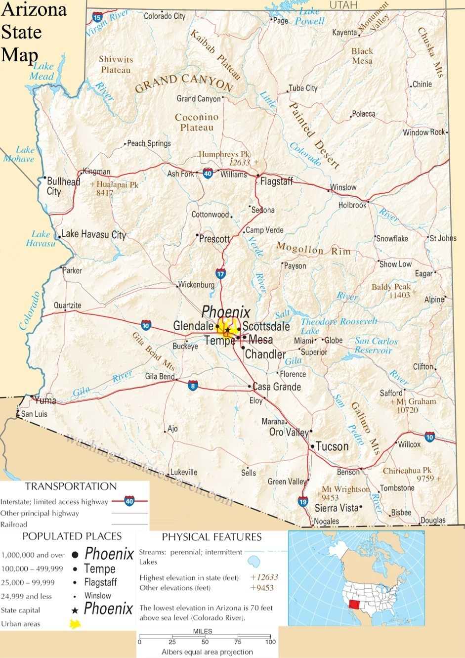
Arizona State Map
Home Page > United States Maps > Arizona State Maps
About Arizona State
Arizona is a southwestern state in the United States known for its diverse landscapes, including deserts, mountains, canyons, and a rich cultural heritage. Here are some key aspects of the State of Arizona:
Geography
Arizona is located in the southwestern region of the United States and shares its borders with California, Nevada, Utah, Colorado, New Mexico, and the country of Mexico to the south. It is the sixth-largest state in the U.S. by land area.
Capital
The capital city of Arizona is Phoenix, which is also the state's largest city. Phoenix is the economic, cultural, and political center of Arizona.
Natural Landscapes
Arizona's geography is incredibly diverse. It is known for its vast deserts, including the Sonoran Desert, as well as the high mountain ranges of the Colorado Plateau, such as the San Francisco Peaks and the White Mountains. The state is home to the Grand Canyon, one of the most iconic natural wonders in the world, which attracts millions of visitors annually.
Native American Culture
Arizona is home to numerous Native American tribes, including the Navajo, Hopi, Apache, and Tohono O'odham, among others. These tribes have a rich cultural heritage and have inhabited the region for centuries. The state features many reservations, pueblos, and cultural sites that showcase their traditions and art.
National Parks and Monuments
Arizona is home to several national parks and monuments. In addition to the Grand Canyon, notable sites include Petrified Forest National Park, Saguaro National Park, and Organ Pipe Cactus National Monument. These parks protect and showcase the unique landscapes and ecosystems of the state.
Outdoor Recreation
The state offers a wide range of outdoor activities, including hiking, rock climbing, mountain biking, and camping. The mild winter climate in many parts of Arizona makes it a popular destination for "snowbirds" seeking to escape cold weather.
Economy
Arizona's economy is diverse, with sectors including manufacturing, agriculture, technology, and tourism. The state has a significant aerospace and defense industry, and it's also a hub for high-tech companies, particularly in the Phoenix metropolitan area.
Education
Arizona is home to several universities and colleges, including Arizona State University, the University of Arizona, and Northern Arizona University. These institutions contribute to the state's educational and research community.
Cultural Attractions
In addition to its natural beauty, Arizona offers cultural attractions such as the Heard Museum in Phoenix, which focuses on Native American art and culture, and the Musical Instrument Museum, featuring a vast collection of musical instruments from around the world.
Challenges
Arizona faces challenges related to water scarcity, as it relies on the Colorado River for a large part of its water supply, which is under increasing pressure due to drought and climate change. The state also deals with immigration and border security issues given its border with Mexico.
In summary, Arizona is a state that offers a wide range of natural and cultural experiences. Its striking landscapes, Native American heritage, and diverse economic activities make it a unique and dynamic part of the United States.
A large detailed map of Arizona State
This is a large detailed map of Arizona State. There are links to street maps of Arizona's 10 largest cities near the bottom of the page.
View our Arizona State county map
From the National Atlas of the United States
United States Department of the Interior.
Arizona State Map
The electronic map of Arizona State that is located below is provided by Google Maps. You can "grab" the Arizona State map and move it around to re-centre the map. You can change between standard map view and satellite map view by clicking the small square on the bottom left hand corner of the map. Satellite map view utilizes orbiting satellite or aerial high resolution photography to display images of the map location to street level detail (really quite amazing). Standard map view shows a traditional street map (also known as a road map). You can use the zoom buttons on the bottom right hand side of the map to zoom in or out to street level detail. We have maps for most towns and cities in the US, so click on the United States Maps link to see more American online maps.
A
B
C
D
E
F
G
H
I
J
K
L
M
N
O
P
Q
R
S
T
U
V
W
X
Y
Z
Arizona State Map