Maps of Buckinghamshire County England
Home > Maps of England > Buckinghamshire County Maps
Welcome to our Buckinghamshire County map page. The map of Buckinghamshire England that is located below is provided by Google Maps. You can "grab" the electronic map and move it around to re-center the map. You can change between standard map view and satellite map view by clicking the small square on the bottom left-hand corner of the map. Satellite map view utilises orbiting satellite and / or aerial high-resolution photography to display images of the map location to street level detail (really quite amazing). Standard map view shows a traditional street map (also known as a road map). You can use the zoom buttons on the bottom right-hand side of the map to zoom in or out to street level detail. We have digital online maps for most towns and cities on the Maps of England page. We also have a good collection of old school printable maps on the Maps of England page.
A map of Buckinghamshire County, England
I hope you like the Buckinghamshire County, England+ 2 End United Kingdom Maps
Buckinghamshire County Maps
Addington |
Adstock |
Amersham |
Ashendon |
Ashley Green |
Aston Abbotts |
Aston Clinton |
Aylesbury
Ballinger Common |
Beaconsfield |
Bledlow |
Bletchley |
Boarstall |
Bourne End |
Bow Brickhill |
Bradenham
Brill |
Buckingham |
Chalfont St Giles |
Chalfont St Peter |
Charndon |
Chartridge |
Cheddington |
Chenies
Chesham |
Cholesbury-cum-St Leonards |
Coleshill |
Cublington |
Cuddington |
Dagnall |
Denham |
Dinton
Dorney |
Downley |
Drayton Parslow |
Edlesborough |
Ellesborough |
Farnham Common |
Farnham Royal
Flackwell Heath |
Fleet Marston |
Gawcott |
Gerrards Cross |
Great Brickhill |
Great Hampden |
Great Horwood
Great Kimble |
Great Kingshill |
Great Missenden |
Grendon Underwood |
Haddenham |
Halton |
Hambleden
Hanslope |
Haversham |
Hazlemere |
High Wycombe |
Holmer Green |
Hughenden |
Ibstone
Ickford |
Iver |
Iver Heath |
Ivinghoe and Pitstone |
Lacey Green |
Lane End |
The Lee |
Lillingstone Dayrell |
Little Chalfont
Little Horwood |
Little Missenden |
Long Crendon |
Loudwater |
Marlow |
Marsworth |
Medmenham |
Mentmore
Middle Claydon |
Milton Keynes |
Mursley |
Nether Winchendon |
Newport Pagnell |
Newton Longville |
North Crawley
Northall |
Olney |
Oving |
Penn and Tylers Green |
Piddington |
Pitstone |
Prestwood |
Princes Risborough |
Quainton
Radnage |
Rowsham |
Saunderton |
Seer Green |
Soulbury |
Speen |
Steeple Claydon |
Stoke Hammond
Stoke Mandeville |
Stoke Poges |
Stokenchurch |
Stone |
Stony Stratford |
Swanbourne |
Taplow |
Thornton |
Tingewick
Turville |
Turweston |
Twyford |
Tylers Green |
Waddesdon |
Wendover |
Westcott |
Weston Turville |
Wexham |
Whaddon
Whitchurch |
Wing |
Wingrave |
Winslow |
Woburn Sands |
Wooburn |
Worminghall |
Wotton Underwood
Buckinghamshire County Map
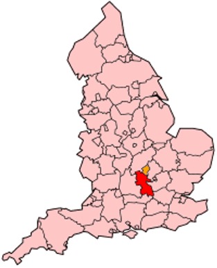
Buckinghamshire is a ceremonial and non-metropolitan home county in South East England. The county town is Aylesbury and the largest town in ceremonial Buckinghamshire is Milton Keynes.
The area under the control of Buckinghamshire County Council, or shire county, is divided into four districts - Aylesbury Vale, Chiltern, South Bucks and Wycombe. The Borough of Milton Keynes is a
unitary authority and forms part of the county for various functions such as Lord Lieutenant but does not come under county council control.
Districts of Buckinghamshire County
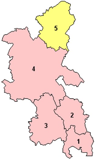
1. South Bucks
2. Chiltern
3. Wycombe
4. Aylesbury Vale
5. Milton Keynes
From Wikipedia, the free encyclopedia