Arthur's Pass New Zealand Information
Home > New Zealand Information > Arthur's Pass Information
Arthur's Pass
Arthur's Pass.
From Wikipedia, the free encyclopedia
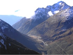
Arthur's Pass is an alpine crossing of the Southern Alps of the South Island of New Zealand. It is at a height of 920 metres above sea level, and marks part of the boundary between Westland and Canterbury, 140 kilometres from Christchurch and 95 kilometres from Greymouth. The pass lies in a saddle between the valleys of the Otira River, a tributary of the Taramakau in the west and the Bealey River in the east.
The pass is named after Sir Arthur Dudley Dobson, who led the first party of Europeans across the pass in 1864. He had been informed of the presence of a pass which had been used occasionally by Maori hunting parties by a West Coast Maori Chief, Tarapuhi. It is also believed that writer and explorer Samuel Butler had seen the pass several years earlier, but was unable to explore it at that time. The timing was perfect, as the West Coast was soon to be hit by a gold rush, and easy access to the Tasman's coast became imperative.
State Highway 73 passes over Arthur's Pass and is the highest of only three roads crossing the Southern Alps, the other crossings being the Haast Pass and Lewis Pass.
Previously prone to be blocked by landslides or avalanches, the road on the western side of the pass has seen extensive civil engineering work in the late 1990s. Most notably, the Otira Viaduct, near the settlement of Otira and spanning 440 meters of unstable terrain, was completed in 1999.
Arthur's Pass Village, a hamlet about 5km south of the pass, is a popular base for exploring Arthurs Pass National Park.