Alaska State Map
Home Page > United States Maps > Alaska State Maps
About Alaska State
Alaska is the largest and northernmost state in the United States, known for its stunning natural landscapes, abundant wildlife, and unique culture. Here are some key aspects of the State of Alaska:
Geography
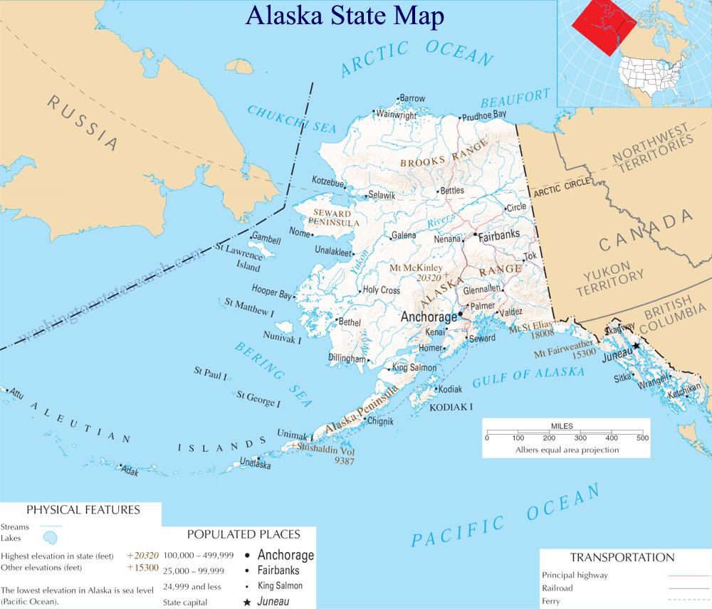
Alaska is located in the far northwest of North America, separated from the contiguous United States by Canada. It is the largest state by land area, covering over 586,412 square miles. The state's geography is incredibly diverse, featuring mountains, glaciers, tundra, forests, and an extensive coastline along the Pacific Ocean and the Arctic Ocean.
Capital
Juneau is the capital of Alaska. It is a long arduous road trip to Juneau along the 1,387-mile Alaska-Canadian Highway (ALCAN) culminating in a ferry ride to the city. Juneau is more easily reached by air. The largest city in the state is Anchorage, which serves as Alaska's economic and cultural hub.
History
Alaska has a rich history, with indigenous peoples, including the Inupiaq, Yupik, and Athabaskan, having inhabited the region for thousands of years. It was purchased from Russia by the United States in 1867 and became a U.S. territory. Alaska gained statehood in 1959, becoming the 49th state of the United States.
Wildlife
Alaska is renowned for its diverse and abundant wildlife. The state is home to iconic animals such as brown bears (grizzly bears), moose, caribou, bald eagles, and marine mammals like whales and sea otters. It is a popular destination for wildlife enthusiasts and photographers.
National Parks and Wilderness
Alaska is home to some of the most spectacular national parks and protected wilderness areas in the United States. These include Denali National Park and Preserve, Wrangell-St. Elias National Park, and Glacier Bay National Park. These areas offer breathtaking scenery, opportunities for hiking, camping, and wildlife viewing.
Natural Wonders
Alaska boasts several natural wonders, including the tallest peak in North America, Denali (formerly known as Mount McKinley), which stands at 20,310 feet (6,190.488 meters). The state is also famous for its numerous glaciers, including the massive Mendenhall Glacier near Juneau.
Economy
The Alaskan economy is heavily reliant on natural resources, including oil, natural gas, and fishing. The Prudhoe Bay oil field on the North Slope is one of the largest in North America. Tourism is also an important industry, with visitors coming to experience the state's pristine wilderness and outdoor activities.
Cultural Diversity
Alaska's population is culturally diverse, with a significant Native Alaskan population. The state is home to various indigenous cultures, each with its own languages, traditions, and art forms. The Alaska Native Heritage Center in Anchorage offers insights into these cultures.
Adventure and Outdoor Activities
Alaska is a paradise for outdoor enthusiasts. Visitors and residents can engage in activities like hiking, fishing, boating, kayaking, skiing, snowmobiling, and dog sledding. The state's vast wilderness areas offer endless opportunities for exploration and adventure.
Challenges
Alaska faces unique challenges, including its remote geography, extreme weather, and the impact of climate change on its environment and communities. Melting glaciers, rising sea levels, and the thawing permafrost are all significant concerns for the state.
In summary, Alaska is a vast and unique state known for its unparalleled natural beauty, wildlife, and outdoor adventures. Its cultural diversity, resource-based economy, and the challenge of adapting to its harsh environment make it a distinctive and fascinating part of the United States.
A large detailed map of Alaska State
This is a large detailed map of Alaska State. There are links to street maps of Alaska's 10 largest cities near the bottom of the page.
View our Alaska State county map
From the National Atlas of the United States
United States Department of the Interior.
Alaska State Map
The electronic map of Alaska State that is located below is provided by Google Maps. You can "grab" the Alaska State map and move it around to re-centre the map. You can change between standard map view and satellite map view by clicking the small square on the bottom left hand corner of the map. Satellite map view utilizes orbiting satellite or aerial high resolution photography to display images of the map location to street level detail (really quite amazing). Standard map view shows a traditional street map (also known as a road map). You can use the zoom buttons on the bottom right hand side of the map to zoom in or out to street level detail. We have maps for most towns and cities in the US, so click on the United States Maps link to see more American online maps.
Anchorage | Barrow | Bethel | Fairbanks | Juneau | Kenai | King Salmon | Kodiak | Sitka | Wasilla