Maps of Bedfordshire England
Home > Maps of England > Bedfordshire Maps
Welcome to our Bedfordshire map page. The map of Bedfordshire England that is located below is provided by Google Maps. You can "grab" the electronic map and move it around to re-center the map. You can change between standard map view and satellite map view by clicking the small square on the bottom left-hand corner of the map. Satellite map view utilises orbiting satellite and / or aerial high-resolution photography to display images of the map location to street level detail (really quite amazing). Standard map view shows a traditional street map (also known as a road map). You can use the zoom buttons on the bottom right-hand side of the map to zoom in or out to street level detail. We have digital online maps for most towns and cities on the Maps of England page. We also have a good collection of old school printable maps on the Maps of England page.
A map of Bedfordshire, England
Bedfordshire Maps
I hope you like the Bedfordshire County, England street map / road map situated above.
If you like our website, please consider adding a link to the site. These links help to build website traffic and they are considered a vote of confidence for a site.
Bedfordshire
Bedfordshire is a county in the East of England. It is a ceremonial county and a historic county, covered by three unitary authorities: Bedford, Central Bedfordshire, and Luton.
Bedfordshire is bordered by Cambridgeshire to the east and northeast, Northamptonshire to the north, Buckinghamshire to the west and Hertfordshire to the southeast and south. It is the fourteenth most densely populated county of England, with over half the population of the county living in the two largest built-up areas: Luton (258,018), and the county town, Bedford (106,940). The highest elevation point is 243 metres (797 ft) on Dunstable Downs in the Chilterns.
History
The first recorded use of the name in 1011 was "Bedanfordscir," meaning the shire or county of Bedford, which itself means "Beda's ford" (river crossing).
Bedfordshire was historically divided into nine hundreds: Barford, Biggleswade, Clifton, Flitt, Manshead, Redbornestoke, Stodden, Willey, Wixamtree, along with the liberty and borough of Bedford. There have been several changes to the county boundary; for example, in 1897 Kensworth and part of Caddington were transferred from Hertfordshire to Bedfordshire.
Geography
The southern end of the county is on the chalk ridge known as the Chiltern Hills. The remainder is part of the broad drainage basin of the River Great Ouse and its tributaries. Most of Bedfordshire's rocks are clays and sandstones from the Jurassic and Cretaceous periods, with some limestone. Local clay has been used for brick-making of Fletton style bricks in the Marston Vale. Glacial erosion of chalk has left the hard flint nodules deposited as gravel-this has been commercially extracted in the past at pits which are now lakes, at Priory Country Park, Wyboston and Felmersham. The Greensand Ridge is an escarpment across the county from near Leighton Buzzard to near Gamlingay in Cambridgeshire.
Bedfordshire Map
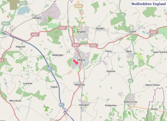
"© OpenStreetMap contributors, CC BY-SA".

Districts of Bedfordshire
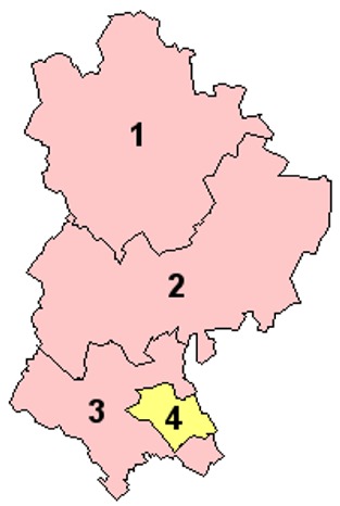
1 - Bedford
2 - Mid Bedfordshire
3 - South Bedfordshire
4 - Luton
From Wikipedia, the free encyclopedia