Manawatu-Wanganui Information
Home > New Zealand Information > Manawatu-Wanganui Information
Manawatu-Wanganui
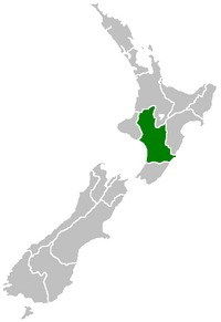
Manawatu Wanganui Region Map.
From Wikipedia, the free encyclopaedia
Manawatu-Wanganui is a region situated in the lower half of the North Island of New Zealand.
Geography
General
The region is dominated and defined by two significant river catchments, Whanganui and Manawatu. The Whanganui River is the longest navigable river in New Zealand. The river was extremely important to early Maori as it was the southern link in a chain of waterways that spanned almost two-thirds of the North Island. It was one of the chief areas of Maori settlement with its easily fortified cliffs and ample food supplies. Legends emphasise the importance of the river and it remains sacred to Wanganui iwi. Maori along the coast and lowland plains grew kumara and other crops.
Much of the Manawatu-Wanganui Region was fertile and bush-covered when Europeans arrived and developed the area as a source of timber. Saw milling and flax milling dominated the 19th century, followed by an influx of sheep farmers who exploited the newly-cleared ground. Deforestation, burn-offs of timber and scrub and large scale drainage combined with overgrazing, resulted in considerable environmental degradation. In the early 1900s authorities realised that careful management was needed to maintain this important agricultural area.
While the open Manawatu Plains became more densely settled by Europeans, inland Ruapehu, Rangitikei and Wanganui remained more Maori-dominated, remote and independent. As late as the 1950s the Whanganui River remained a river of mystery. More recently, however, exploitation of the river's commercial potential has opened up the area, often causing friction with local Maori who have longstanding grievances. The region has remained one of the most important pastoral areas in New Zealand, its status recognised when the government opened the Massey Agricultural College in the 1920s.
Topography
The Manawatu-Wanganui Region takes up a large proportion of the lower half of the North Island. It is the second-largest region in the North Island and the sixth-largest region in New Zealand, totalling 22,215 Km2 (8.1% of New Zealand's total land area). The region stretches from north of Taumarunui to south of Levin on the west coast, and across to the east coast from Cape Turnagain to Owhanga. It borders the Waikato, Taranaki, Hawke's Bay and Wellington Regions and includes river catchment areas that run from the volcanic plateau to the sea. The Pacific Ocean marks the eastern border and the Ruahine Ranges form a natural boundary between the region and Hawke's Bay. There are 10 territorial authorities within the region but five of these straddle the boundary with other regions.
This extensive area includes a variety of landscape formations. Districts close to the Volcanic Plateau are higher and more rugged, often subject to harsh temperatures in winter. The Manawatu District has a much gentler topography, consisting mainly of the flat, tree studded Manawatu Plains that run between the ranges and the sea. The land was under the sea till about 500,000 years ago and still has a very thick layer of marine sediment, which is about five or six million years old. A block faulting system underneath the thick sediment has raised a series of domes and gentle depressions. These structures can provide natural storage areas for oil and some of the Manawatu domes have been drilled. The domes have shaped the course of the Manawatu River, giving it a meandering path which, uniquely among New Zealand rivers, begins close to the east coast and exits on the west coast. The Manawatu River begins just inside the Hawke's Bay Region then flows through a deep gorge to the Manawatu Plains before exiting in the Tasman Sea. The Wanganui District is more rugged, with canyon-like valleys and gorges carved out of the soft rock by rivers and ocean waves.
The region includes a series of mountain ranges - notably the Tararua and the Ruahine Ranges - as well as the three major active volcanoes of the North Island. This triumvirate towers above the Volcanic Plateau. Mount Ruapehu, at 2,797 metres, is the tallest mountain in the North Island, Ngauruhoe reaches 2,291 metres and Tongariro 1,968 metres. During the last 100 years, Ruapehu has experienced six significant eruptions and has erupted as recently as 1995 and 1996.
Three major rivers divide the region: the Whanganui (290 kilometres), Manawatu (182 kilometres) and Rangitikei (241 kilometres). The Whanganui is the second-longest river and has the second-largest catchment in the North Island and drains most of the inland region west of Lake Taupo. There are few roads in this area, which contains some of the largest surviving areas of native bush in the North Island.
Soil and climate
Soils in the region are productive with the addition of fertiliser. In the Manawatu and Horowhenua Districts there are sandy soils and swampy hollows around the coast with loess-covered terraces and river flats inland. These river flats and swamp areas contain fertile alluvial and organic soils. On the drier terraces inland yellow-grey earths predominate. The flatter more fertile soils suit intensive sheep farming and cropping while the hill country of Rangitikei favours semi-intensive sheep and beef farming. Areas close to the volcanic plateau consist largely of pumice soils which lack some essential trace elements but within the region much of this land is occupied by national parks.
The Manawatu-Wanganui Region has a comparatively mild climate although there are greater climatic extremes inland. Chateau Tongariro experienced the lowest temperature ever recorded in the North Island, falling to -13.6 ºC on 7 July 1937. In summer the region is warm, with a maximum mid-summer daily average of between 20.1 and 22.9 ºC. Sunshine hours approximate the national average for much of the region (between 1,800 and 2,000 hours per annum) but Palmerston North is defined as cloudy with an average of 1,725 sunshine hours a year. In the winter the minimum mid-winter daily average for coastal areas is a cool 4.0 to 7.9 ºC, while inland areas are considerably colder. Waiouru averages a minimum mid-winter daily average of 0.1 ºC.
Rainfall on the plains is slightly below average, with Palmerston North receiving an annual average of 960 millimetres, while the rest of the region receives the New Zealand average rainfall of between 1,000 and 2,000 millimetres per annum.
Conservation and parks
The Manawatu-Wanganui Region contains areas of great ecological significance, which is reflected in the designation of approximately a seventh of its land area as part of the nation's conservation estate. Tongariro National Park is the largest park in the region (795.98 km2) and is the oldest national park in the country, established in 1887. The volcanoes Tongariro, Ruapehu and Ngauruhoe are sacred to Maori and were gifted to the nation by Te Heuheu Tukino IV, paramount chief of Ngati Tuwharetoa. They form the nucleus of the park, which is now designated a world heritage area.
The Whanganui National Park is slightly smaller (742.31 km2) and was established 99 years later when a series of reserves were incorporated into one area and given national park status. There are also two state forest parks situated in the rugged, bush-clad Ruahine and Tararua Ranges. The four parks offer skiing, tramping, jetboating and white-water rafting as well as the opportunity to appreciate the environment.
The regional council, responsible for managing natural and physical resources, provides flood protection and monitors environmental problems such as pest infestation and pollution. Invasive plant pests such as African feathergrass, goats rue and nodding thistle pose a threat to pastureland in this heavily agricultural-dependent region, and the regional council has instituted control campaigns. The regional council has also instituted animal pest control programmes. Possums are perceived as the major animal pest since they damage native forests and endanger cattle production through the spread of bovine tuberculosis. Eradication programmes also concentrate on rabbits, rooks and feral goats, while other exotic species such as dama wallaby, wasps, ferrets, stoats and weasels are a source of concern.