┬®2011 Google - Code Home -
Site Terms of Service - Privacy Policy - Site Directory
Google Code
offered in: English - Espa├▒ol - µŚźµ£¼Ķ¬× - ĒĢ£ĻĄŁņ–┤ - Portugu├¬s - Pčāčüčüą║ąĖą╣ - õĖŁµ–ć(ń«ĆõĮō) - õĖŁµ–ć(ń╣üķ½ö)
-
Static Maps API
-
Maps JavaScript API V3
-
Maps Javascript API V2
(Deprecated API)
-
Maps API for Flash
-
Maps Data API
(Deprecated API)
-
Earth API
-
Local Search API
(Deprecated API)
Includes enterprise licensing and support
Static Maps API V2 Developer Guide
Welcome to the developer documentation for the Google Static Maps API! The Google Static Maps API lets you embed a Google Maps image on your webpage without requiring JavaScript or any dynamic page loading. The Google Static Map service creates your map based on URL parameters sent through a standard HTTP request and returns the map as an image you can display on your web page.
Note: The Google Static Maps API
no longer requires a Maps API key!
(Google Maps API Premier customers
should instead sign their URLs using a new cryptographic key which will
be sent to you. See the Premier
documentation for more information.)
New! The Google Static Maps service now supports custom styled maps!
If you just want to quickly change your existing Static Maps URLs to use the new API, consult this Upgrade Guide.
A Quick Example
The following example contains the URL of a static map image of downtown New York City, which is displayed below:
http://maps.google.com/maps/api/staticmap?center=Brooklyn+Bridge,New+York,NY&zoom=14&size=512x512&maptype=roadmap
&markers=color:blue%7Clabel:S%7C40.702147,-74.015794&markers=color:green%7Clabel:G%7C40.711614,-74.012318
&markers=color:red%7Ccolor:red%7Clabel:C%7C40.718217,-73.998284&sensor=false
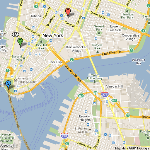
Notice that you don't need to do anything "special" to get this image to show
up on the page. No JavaScript is required. All we needed to do was create a URL,
and place it within an <img> tag. You can place a Google
static map anywhere on your webpage where you can place an image.
Contents
Audience
This document is intended for website and mobile developers who want to include Google Static Maps API images within a webpage. It provides an introduction to using the API and reference material on the available parameters.
Usage Limits
Use of the Google Static Maps API is subject to a query limit of 1000 unique (different) image requests per viewer per day. Since this restriction is a quota per viewer, most developers should not need to worry about exceeding their quota. However, note that we enforce an additional request rate limit to prevent abuse of the service. Requests of identical images, in general, do not count towards this limit beyond the original request.
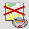
If a user exceeds the limit as proscribed above, the following image will be displayed indicating that the quota has been exceeded:
This limit is enforced to prevent abuse and/or repurposing of the Static Maps API, and this limit may be changed in the future without notice. If you exceed the 24-hour limit or otherwise abuse the service, the Static Maps API may stop working for you temporarily. If you continue to exceed this limit, your access to the Static Maps API may be blocked.
Static Map URLs are restricted to 2048 characters in size. In practice, you will probably not have need for URLs longer than this, unless you produce complicated maps with a high number of markers and paths. Note, however, that certain characters may be URL-encoded by browsers and/or services before sending them off to the Static Map service, resulting in increased character usage. For more information, see Building a Valid URL.
Overview
The Google Static Maps API returns an image (either GIF, PNG or JPEG) in response to a HTTP request via a URL. For each request, you can specify the location of the map, the size of the image, the zoom level, the type of map, and the placement of optional markers at locations on the map. You can additionally label your markers using alphanumeric characters, so that you can refer to them in a "key."
You embed a Static Maps API image within a webpage inside an
<img> tag's src attribute. When the webpage is
displayed, the browser requests the image from the the Static Maps API and it
renders within the image location. Note that static maps may only be displayed
within browser content; use of static maps outside of the browser is not
allowed. (Google Maps API
Premier users are waived of this requirement.)
This document describes the required format of Static Maps API URLs and the available parameters. It also points out some tips and tricks in specifying your URLs.
URL Parameters
A Google Static Maps API URL must be of the following form:
http://maps.google.com/maps/api/staticmap?parameters
If your website is accessed over HTTPS, you must load Static Map images over HTTPS as well in order to avoid browser security alerts. HTTPS is also recommended if your requests include sensitive user information, such as a user's location:
https://maps.googleapis.com/maps/api/staticmap?parameters
Note that the Static Maps API does not support custom icon URLs that use HTTPS; the default icon will be displayed.
Whether using HTTP or HTTPS, certain URL parameters are required while some
are optional. As is standard in URLs, all parameters are separated using the
ampersand (&) character. The list of parameters and their
possible values are enumerated below.
Important: The
discussion of URL parameters below use examples that for clarity are given in
their pre-escaping form. Before sending any request to the API, its parameters
should be properly URL
encoded. For example, many parameters use a pipe character (|)
as a separator, which should be encoded as %7C in the final URL, as
in the quick example at the top of this document.
The Static Maps API defines map images using the following URL parameters:
center(required if markers not present) defines the center of the map, equidistant from all edges of the map. This parameter takes a location as either a comma-separated {latitude,longitude} pair (e.g. "40.714728,-73.998672") or a string address (e.g. "city hall, new york, ny") identifying a unique location on the face of the earth. For more information, see Locations below.zoom(required if markers not present) defines the zoom level of the map, which determines the magnification level of the map. This parameter takes a numerical value corresponding to the zoom level of the region desired. For more information, see zoom levels below.size(required) defines the rectangular dimensions of the map image. This parameter takes a string of the formvaluexvaluewhere horizontal pixels are denoted first while vertical pixels are denoted second. For example,500x400defines a map 500 pixels wide by 400 pixels high. If you create a static map that is 100 pixels wide or smaller, the "Powered by Google" logo is automatically reduced in size.format(optional) defines the format of the resulting image. By default, the Static Maps API creates PNG images. There are several possible formats including GIF, JPEG and PNG types. Which format you use depends on how you intend to present the image. JPEG typically provides greater compression, while GIF and PNG provide greater detail. For more information, see Image Formats.maptype(optional) defines the type of map to construct. There are several possible maptype values, includingroadmap,satellite,hybrid, andterrain. For more information, see Static Maps API Maptypes below.language(optional) defines the language to use for display of labels on map tiles. Note that this parameter is only supported for some country tiles; if the specific language requested is not supported for the tile set, then the default language for that tileset will be used.markers(optional) define one or more markers to attach to the image at specified locations. This parameter takes a single marker definition with parameters separated by the pipe character (|). Multiple markers may be placed within the samemarkersparameter as long as they exhibit the same style; you may add additional markers of differing styles by adding additionalmarkersparameters. Note that if you supply markers for a map, you do not need to specify the (normally required)centerandzoomparameters. For more information, see Static Map Markers below.path(optional) defines a single path of two or more connected points to overlay on the image at specified locations. This parameter takes a string of point definitions separated by the pipe character (|). You may supply additional paths by adding additionalpathparameters. Note that if you supply a path for a map, you do not need to specify the (normally required)centerandzoomparameters. For more information, see Static Map Paths below.visible(optional) specifies one or more locations that should remain visible on the map, though no markers or other indicators will be displayed. Use this parameter to ensure that certain features or map locations are shown on the static map.style(optional) defines a custom style to alter the presentation of a specific feature (road, park, etc.) of the map. This parameter takesfeatureandelementarguments identifying the features to select and a set of style operations to apply to that selection. You may supply multiple styles by adding additionalstyleparameters. For more information, see Styled Maps below.sensor(required) specifies whether the application requesting the static map is using a sensor to determine the user's location. This parameter is required for all static map requests. For more information, see Denoting Sensor Usage below.
Location Parameters:
Map Parameters:
Feature Parameters:
Reporting Parameters:
Parameter Usage
The Static Maps API is relatively easy to use, as it consists solely of a parameterized URL. This section explains how to use these parameters to construct your URLs.
Specifying Locations
The Static Maps API must be able to precisely identify locations on the map,
both to focus the map at the correct location (using the center
parameter) and/or to place any optional placemarks (using the
markers parameter) at locations on the map. The Static Maps API
uses numbers (latitude and longitude values) or strings (addresses) to specify
these locations. These values identify a geocoded location.
Several parameters (such as the markers and path
parameters) take multiple locations. In those cases, the locations are separated
by the pipe (|) character.
Latitudes and Longitudes
Latitudes and longitudes are defined using numerals within a comma-separated text string that have a precision to 6 decimal places. For example, "40.714728,-73.998672" is a valid geocode value. Precision beyond the 6 decimal places is ignored.
Longitude values are based on their distance from Greenwich, England, home of
the prime meridian. Since Greenwich is situated at 51.477222 latitude, we can
enter a center value of 51.477222,0 to center the map
on Greenwich:
.png)
Latitude and longitude values must correspond to a valid location on the face
of the earth. Latitudes can take any value between -90 and
90 while longitude values can take any value between
-180 and 180. If you specify an invalid latitude or
longitude value, your request will be rejected as a bad request.
Addresses
Most people don't speak in latitudes and longitudes; they denote locations using addresses. The process of turning an address into a geographic point is known as geocoding and the Static Maps service can perform geocoding for you if you provide valid addresses.
In any parameter where you may provide a latitude/longitude, you may instead specify a string indicating an address. Google will geocode the address and provide the Static Map service with a latitude/longitude value to use in placing markers or specifying locations. The string should be URL-escaped, so addresses such as "City Hall, New York, NY" should be converted to "City+Hall,New+York,NY", for example.
Note that addresses may reflect either precise locations, such as street addresses, polylines such as named routes, or polygonal areas such as cities, countries, or national parks. For polylinear and polygonal results, the Static Map server will use the center point of the line/area as the address center. If you have doubt about how an address may geocode, you can test out the address using this Geocoding Utility.
The following example generates a static map for Berkeley, CA:
http://maps.google.com/maps/api/staticmap?center=Berkeley,CA&zoom=14&size=400x400&sensor=false
.png)
Denoting Sensor Usage
Use of the Google Static Maps API requires that you indicate whether your application is using a "sensor" (such as a GPS locator) to determine the user's location. This is especially important for mobile devices. Applications must pass a required sensor parameter indicating whether or not your application is using a sensor device.
Applications that determine the user's location via a sensor must pass
sensor=true within your Static Maps API request URL. If your
application does not use a sensor, pass sensor=false.
Zoom Levels
Maps on Google Maps have an integer "zoom level" which defines the resolution
of the current view. Zoom levels between 0 (the lowest zoom level,
in which the entire world can be seen on one map) to 21+ (down to
individual buildings) are possible within the default roadmap maps view.
Google Maps sets zoom level 0 to encompass the entire earth.
Each succeeding zoom level doubles the precision in both horizontal and vertical
dimensions. More information on how this is done is available in the Google
Maps API documentation.
Note: not all zoom levels appear at all locations on the earth. Zoom levels vary depending on location, as data in some parts of the globe is more granular than in other locations.
If you send a request for a zoom level in which no map tiles exist, the Static Maps API will return a blank image instead.
The example below requests two maps of Manhattan at the same
center value but at zoom levels 12 and 14, respectively:
http://maps.google.com/maps/api/staticmap?center=40.714728,-73.998672&zoom=12&size=400x400&sensor=false
http://maps.google.com/maps/api/staticmap?center=40.714728,-73.998672&zoom=14&size=400x400&sensor=false
.png)
.png)
Image Sizes
Images may be retrieved in sizes up to 640 by 640 pixels. The
size parameter takes a string with two values separated by the
x character. 640x640 is the largest image size
allowed. Note that the center parameter, combined with the
size parameter implicitly defines the coverage area of the map
image.
The example below requests a "slice" of the earth at the equator at zoom level 1:
http://maps.google.com/maps/api/staticmap?center=0,0&zoom=1&size=400x50&sensor=true_or_false
.png)
The example below requests a small map, of size 100 x 100 pixels centered on the same region. Note the smaller Google logo:
.png)
Image Formats
Images may be returned in several common web graphics formats: GIF,
JPEG and PNG. The format parameter takes one of the
following values:
png8orpng(default) specifies the 8-bit PNG format.png32specifies the 32-bit PNG format.gifspecifies the GIF format.jpgspecifies the JPEG compression format.jpg-baselinespecifies a non-progressive JPEG compression format.
jpg and jpg-baseline typically provide the smallest
image size, though they do so through "lossy" compression which may degrade the
image. gif, png8 and png32 provide
lossless compression.
Most JPEG images are progressive, meaning that they load a coarser image
earlier and refine the image resolution as more data arrives. This allows images
to be loaded quickly in webpages and is the most widespread use of JPEG
currently. However, some uses of JPEG (especially printing) require
non-progressive (baseline) images. In such cases, you may want to use the
jpg-baseline format, which is non-progressive.
Map Types
The Google Static Maps API creates maps in several formats, listed below:
roadmap(default) specifies a standard roadmap image, as is normally shown on the Google Maps website. If nomaptypevalue is specified, the Static Maps API servesroadmaptiles by default.satellitespecifies a satellite image.terrainspecifies a physical relief map image, showing terrain and vegetation.hybridspecifies a hybrid of the satellite and roadmap image, showing a transparent layer of major streets and place names on the satellite image.
You can see the difference between roadmap and terrain types in the code example below.
http://maps.google.com/maps/api/staticmap?center=40.714728,-73.998672&zoom=12&size=400x400&maptype=roadmap&sensor=true_or_false
http://maps.google.com/maps/api/staticmap?center=40.714728,-73.998672&zoom=12&size=400x400&maptype=terrain&sensor=true_or_false
.png)
Hybrid maps use satellite images and prominent roadmap features to create a combination map. The following examples show satellite and hybrid map types:
http://maps.google.com/maps/api/staticmap?center=40.714728,-73.998672&zoom=12&size=400x400&maptype=satellite&sensor=true_or_false
http://maps.google.com/maps/api/staticmap?center=40.714728,-73.998672&zoom=12&size=400x400&maptype=hybrid&sensor=true_or_false
.png)
.png)
Styled Maps
Styled maps allow you to customize the presentation of the standard Google map styles, changing the visual display of such elements as roads, parks, and built-up areas to reflect a different style than that used in the default map type. These components are known as features and a styled map allows you to select these features and apply visual styles to their display (including hiding them entirely). With these changes, the map can be made to emphasize particular components or complement content within the surrounding page.
A customized "styled" map consists of one or more specified styles, each
indicated through a style parameter within the Static Map request
URL. Additional styles are specified by passing additional style
parameters. A style consists of a selection(s) and a set of rules
to apply to that selection. The rules indicate what visual modification to make
to the selection.
Each style declaration consists of the following arguments,
separated using a pipe ("|") character within the
style declaration:
feature(optional) indicates what features to select for this style modification. (See Map Features below.) If nofeatureargument is passed, all features will be selected.element(optional) indicates what sub-set of the selected features to select. (See Map Elements below.) If noelementargument is passed, all elements of the given feature will be selected.- Any following arguments indicate the rule(s) to apply to the above
selection. All rules are applied in the order in which they appear within the
styledeclaration. (See Style Rules below.) Any number of rules may follow a feature selection, within the normal URL-length constraints of the Static Maps API.
Note: the style declaration must specify the above arguments in
the order stated. For example, a feature selection with two rules would appear
as show below:
style=feature:featureArgument|element:elementArgument|rule1:rule1Argument|rule2:rule2Argument
Map Features
A map consists of a set of features, such as roads or parks. The
feature types form a category tree, with feature:all as the root.
Some common features are listed below:
feature:all(default) selects all features of the map.feature:roadselects all roads on the map.feature:landscapeselects all background landscapes on a map, which is often the area between roads, for example. In cities, landscape usually consists of built-up areas.
The full list of features for selection within a map is documented in the Maps Javascript API V3 reference.
Some feature type categories contain sub-categories which are specified using
a dotted notation (landscape.natural or road.local,
for example). If the parent feature (road, for example) is
specified, then styles applied to this selection will be applied to all roads,
including sub-categories.
Map Feature Elements
Additionally, some features on a map typically consist of different
elements. A road, for example, consists of not only the graphical line
(geometry) on the map, but the text denoting its name (labels) attached the map.
Elements within features are selected by declaring an element
argument. The following element argument values are supported:
element:all(default) selects all elements of that feature.element:geometryselects only geometric elements of that feature.element:labelsselects only textual labels associated with that feature.
If no element argument is passed, styles will be applied to all elements of the feature regardless of element type.
The following style declaration selects the labels for all local
roads:
style=feature:road.local|element:labels
Style Rules
Style rules are formatting options which are applied to the features and
elements specified within each style declaration. Each
style declaration must contain one or more operations separated
using the pipe ("|") character. Each operation specifies its
argument value using the colon (":") character, and all operations
are applied to the selection in the order in which they are specified.
The following operation arguments, and the values that take, are currently supported:
hue(an RGB hex string of format0xRRGGBB) indicates the basic color to apply to the selection. (* See usage note below.)lightness(a floating point value between-100and100) indicates the percentage change in brightness of the element. Negative values increase darkness (where -100 specifies black) while positive values increase brightness (where +100 specifies white).saturation(a floating point value between-100and100) indicates the percentage change in intensity of the basic color to apply to the element.gamma(a floating point value between0.01and10.0, where1.0applies no correction) indicates the amount of gamma correction to apply to the element. Gammas modify the lightness of hues in a non-linear fashion, while unaffecting white or black values. Gammas are typically used to modify the contrast of multiple elements. For example, you could modify the gamma to increase or decrease the contrast between the edges and interiors of elements. Low gamma values (< 1) increase contrast, while high values (> 1) decrease contrast.inverse_lightness:truesimply inverts the existing lightness.visibility(on,off, orsimplified) indicates whether and how the element appears on the map.visibility:simplifiedindicates that the map should simplify the presentation of those elements as it sees fit. (A simplified road structure may show fewer roads, for example.)
Style rules must be applied as separate, distinct operations, and are applied
in the order they appear within the style declaration. Order is
important, as some operations are not commutative. Features and/or elements that
are modified through style operations (usually) already have existing styles;
the operations act on those existing styles, if present.
Note that we use the Hue,
Saturation, Lightness (HSL) model to denote color within the styler
operations. These operations to define color are common within graphic design.
Hue indicates the basic color, saturation indicates the intensity
of that color, and lightness indicates the relative amount of white or
black in the constituent color. All three HSL values can be mapped to RGB values
(and vice versa). Gamma
correction acts to modify saturation over the color space, generally to
increase or decrease contrast. Additionally, the HSL model defines color within
a coordinate space where hue indicates the orientation within a
color wheel, while saturation and lightness indicate amplitudes along different
axes. Hues are measured within an RGB color space, which is similar to most RGB
color spaces, except that shades of white and black are absent.
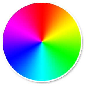
An RGB Color Wheel
Note: while hue takes an RGB hex
color value, it only uses this value to determine the basic color (its
orientation around the color wheel), not its saturation or lightness, which are
indicated separately as percentage changes. For example, the hue for pure green
may be defined as hue:0x00ff00 or hue:0x000100 and
both hues will be identical. (Both values point to pure green in the HSL color
model.) RGB hue values which consist of equal parts Red, Green and
Blue ŌĆö such as hue:0x0000000 (black) and hue:0xffffff
(white) and all the pure shades of grey ŌĆö do not indicate a hue whatsoever, as
none of those values indicate an orientation in the HSL coordinate space. To
indicate black, white or grey, you must remove all saturation (add
a saturation:-100 operation) and adjust lightness
instead.
Additionally, when modifying existing features which already have a color
scheme, changing a value such as hue does not change its existing
saturation or lightness.
The following example displays a map of Brooklyn where local roads have been changed to bright green and the residential areas have been changed to black (note that in this fully worked example the pipe separators have been properly URL encoded; see the note above):
http://maps.google.com/maps/api/staticmap?sensor=false&size=512x512¢er=Brooklyn&zoom=12&style=feature:road.local%7Celement:geometry%7Chue:0x00ff00%7Csaturation:100&style=feature:landscape%7Celement:geometry%7Clightness:-100
.png)
The following more complicated example uses several operations and simplifications to approximate the look of a US road atlas:
http://maps.google.com/maps/api/staticmap?sensor=false&size=512x512&zoom=11¢er=Chicago&style=feature:road.highway%7Celement:geometry%7Chue:0xff0022%7Csaturation:60%7Clightness:-20&style=feature:road.arterial%7Celement:geometry%7Chue:0x2200ff%7Clightness:-40:visibility:simplified%7Csaturation:30&style=feature:road.local%7Chue:0xf6ff00%7Csaturation:60%7Cgamma:0.7%7Cvisibility:simplified&style=feature:water%7Celement:geometry%7Csaturation:40%7Clightness:40&style=road.highway%7Celement:labels%7Cvisibility:on%7Csaturation:98&style=feature:administrative.locality%7Celement:labels%7Chue:0x0022ff%7Csaturation:50%7Clightness:-10%7Cgamma:0.9&style=feature:transit.line%7Celement:geometry%7Chue:0xff0000%7Cvisibility:on%7Clightness:-70
.png)
Markers
The markers parameter defines a set of one or more markers at a
set of locations. Each marker defined within a single markers
declaration must exhibit the same visual style; if you wish to display markers
with different styles, you will need to supply multiple markers
parameters with separate style information.
The markers parameter takes set of value assignments (marker
descriptors) of the following format:
markers=markerStyles|markerLocation1|
markerLocation2|...
etc.
The set of markerStyles is declared at the beginning of the
markers declaration and consists of zero or more style descriptors
separated by the pipe character (|), followed by a set of one or
more locations also separated by the pipe character (|).
Because both style information and location information is delimited via the pipe character, style information must appear first in any marker descriptor. Once the Static Map server encounters a location in the marker descriptor, all other marker parameters are assumed to be locations as well.
Marker Styles
The set of marker style descriptors is a series of value assignments
separated by the pipe (|) character. This style descriptor defines
the visual attributes to use when displaying the markers within this marker
descriptor. These style descriptors contain the following key/value
assignments:
size:(optional) specifies the size of marker from the set{tiny, mid, small}. If nosizeparameter is set, the marker will appear in its default (normal) size.-
color:(optional) specifies a 24-bit color (example:color=0xFFFFCC) or a predefined color from the set{black, brown, green, purple, yellow, blue, gray, orange, red, white}.Note that transparencies (specified using 32-bit hex color values) are not supported in markers, though they are supported for paths.
label:(optional) specifies a single uppercase alphanumeric character from the set {A-Z, 0-9}. (The requirement for uppercase characters is new to this version of the API.) Note that default andmidsized markers are the only markers capable of displaying analphanumeric-characterparameter.tinyandsmallmarkers are not capable of displaying an alphanumeric-character.
Note: instead of using these markers, you may wish to use your own custom icon. (For more information, see Custom Icons below.)
Marker Locations
Each marker descriptor must contain a set of one or more locations defining
where to place the marker on the map. These locations may be either specified as
latitude/longitude
values or as addresses.
These locations are separated using the pipe character (|).
The location parameters define the marker's location on the map. If the
location is off the map, that marker will not appear in the constructed image
provided that center and zoom parameters are supplied.
However, if these parameters are not supplied, the Static Map server will
automatically construct an image which contains the supplied markers. (See Implicit
Positioning below.)
A sample marker declaration is shown below. Note that we define one set of styles and three locations:
http://maps.google.com/maps/api/staticmap?center=Williamsburg,Brooklyn,NY&zoom=13&size=400x400&
markers=color:blue%7Clabel:S%7C11211%7C11206%7C11222&sensor=true_or_false
.png)
To define markers with differing styles, we need to supply multiple
markers parameters. This set of markers parameters
defines three markers: one blue marker labeled "S" at 62.107733, -145.5419, one
tiny green marker at "Delta Junction, AK", and one mid-sized yellow marker
labeled "C" at "Tok, AK". These markers are shown in the example below:
http://maps.google.com/maps/api/staticmap?center=63.259591,-144.667969&zoom=6&size=400x400\
&markers=color:blue%7Clabel:S%7C62.107733,-145.541936&markers=size:tiny%7Ccolor:green%7CDelta+Junction,AK\
&markers=size:mid%7Ccolor:0xFFFF00%7Clabel:C%7CTok,AK&sensor=false" />
.png)
Custom Icons
Rather than use Google's marker icons, you are free to use your own custom
icons instead. Custom icons are specified using the following descriptors to the
markers parameter:
iconspecifies a URL to use as the marker's custom icon. Images may be in PNG, JPEG or GIF formats, though PNG is recommended.shadow(defaulttrue) indicates that the Static Maps service should construct an appropriate shadow for the image. This shadow is based on the image's visible region and its opacity/transparency.
The icon parameter must be specified using a URL (which should
be URL-encoded). You may
use any valid URL of your choosing, or a URL-shortening service such as
http://bit.ly or http://tinyurl.com. Most
URL-shortening services have the advantage of automatically encoding URLs. Icons
are limited to sizes of 4096 pixels (64x64 for square images), and the Static
Maps service allows up to five unique custom icons per request. Note that each
of these unique icons may be used multiple times within the static map.
Custom icons that have a shadow:true descriptor (the default)
will have their "anchor point" set as the bottom center of the provided icon
image, from which the shadow is cast. Icons without a shadow (setting a
shadow:false descriptor) are instead assumed to be icons centered
on their specified locations, so their anchor points are set as the center of
the image.
The following example uses Google's Chart API to create custom markers, showing several coffee shops in New York City:
http://maps.google.com/maps/api/staticmap?size=480x480&markers=
icon:http://chart.apis.google.com/chart?chst=d_map_pin_icon%26chld=cafe%257C996600%7C
224+West+20th+Street%7C75+9th+Ave%7C700+E+9th+St&sensor=true_or_false
.png)
Note: The multiple levels of escaping above
may be confusing. The Google Chart API uses the pipe character (|)
to delimit strings within its URL parameters. Since this character is not legal
within a URL (see the note
above), when creating a fully valid chart URL it is escaped to %7C.
Now the result is embedded as a string in an icon specification,
but it contains a % character (from the %7C mentioned
above), which cannot be included directly as data in a URL and must be escaped
to %25. The result is that the URL contains %257C,
which represents two layers of encoding. Similarly, the chart URL contains an
& character, which cannot be included directly without being
confused as a separator for static map URL parameters, so it too must be
encoded.
Here are the steps of creating the static map URL:
# Intended chld parameter:
chld=cafe|996600

# Embedded in a fully valid chart URL:
http://chart.apis.google.com/chart?chst=d_map_pin_icon&chld=cafe%7C996600

# Intended icon parameter, containing a fully valid URL:
markers=icon:http://chart.apis.google.com/chart?chst=d_map_pin_icon&chld=cafe%7C996600

# Embedded in a valid and unambiguous static map URL:
...&markers=icon:http://chart.apis.google.com/chart?chst=d_map_pin_icon%26chld=cafe%257C996600
Static Map Paths
The path parameter defines a set of one or more locations
connected by a path to overlay on the map image. The path parameter
takes set of value assignments (path descriptors) of the following
format:
path=pathStyles|pathLocation1|pathLocation2|...
etc.
Note that both path points are separated from each other using the pipe
character (|). Because both style information and point information
is delimited via the pipe character, style information must appear first in any
path descriptor. Once the Static Map server encounters a location in the path
descriptor, all other path parameters are assumed to be locations as well.
Path Styles
The set of path style descriptors is a series of value assignments separated
by the pipe (|) character. This style descriptor defines the visual
attributes to use when displaying the path. These style descriptors contain the
following key/value assignments:
weight:(optional) specifies the thickness of the path in pixels. If noweightparameter is set, the path will appear in its default thickness (5 pixels).-
color:(optional) specifies a color either as a 24-bit (example:color=0xFFFFCC) or 32-bit hexadecimal value (example:color=0xFFFFCCFF), or from the set{black, brown, green, purple, yellow, blue, gray, orange, red, white}.When a 32-bit hex value is specified, the last two characters specify the 8-bit alpha transparency value. This value varies between
00(completely transparent) andFF(completely opaque). Note that transparencies are supported in paths, though they are not supported for markers. fillcolor:(optional) indicates both that the path marks off a polygonal area and specifies the fill color to use as an overlay within that area. The set of locations following need not be a "closed" loop; the Static Map server will automatically join the first and last points. Note, however, that any stroke on the exterior of the filled area will not be closed unless you specifically provide the same beginning and end location.
Some example path definitions appear below:
- Thin blue line, 50% opacity:
path=color:0x0000ff|weight:1 - Solid red line:
path=color:0xff0000ff|weight:5 - Solid thick black line:
path=color:0xffffffff|weight:10
These path styles are optional. If default attributes are desired, you may skip defining the path attributes; in that case, the path descriptor's first "argument" will consist instead of the first declared point (location).
Path Points
In order to draw a path, the path parameter must also be passed
two or more points. The Google Static Maps API will then connect the path along
those points, in the specified order. Each pathPoint is denoted in the
pathDescriptor separated by the | (pipe) character.
The following example defines a blue path with default 50% opacity from Union Square NY to Times Square, NY.
.png)
The specifics of the path parameter appear below:
path=color:0x0000ff|weight:5|40.737102,-73.990318|40.749825,-73.987963|40.752946,-73.987384|40.755823,-73.986397
The following example defines the same path instead defining a solid red line with 100% opacity:
.png)
The specifics of this path parameter appear below:
path=color:0xff0000ff|weight:5|40.737102,-73.990318|40.749825,-73.987963|40.752946,-73.987384|40.755823,-73.986397
The example below defines a polygonal area within Manhattan, passed a series of intersections as locations:
.png)
The specifics of this path parameter appear below:
path=color:0x00000000|weight:5|fillcolor:0xFFFF0033|8th+Avenue+%26+34th+St,New+York,NY|\
8th+Avenue+%26+42nd+St,New+York,NY|Park+Ave+%26+42nd+St,New+York,NY,NY|\
Park+Ave+%26+34th+St,New+York,NY,NY
Note that we set the path itself to be invisible and the polygonal area to have a 15% opacity.
Encoded Polylines
Instead of a series of locations, you may instead declare a path as an encoded
polyline by using the enc: prefix within the location
declaration of the path. Note that if you supply an encoded
polyline path for a map, you do not need to specify the (normally required)
center and zoom parameters.
The following example outlines the course of the Alaska Highway from Dawson Creek, BC to Delta Junction, AK with an encoded polyline:
http://maps.google.com/maps/api/staticmap?size=400x400&path=weight:3%7Ccolor:orange%7Cenc:polyline_data
.png)
As with standard paths, encoded polyline paths may also demarcate polygonal
areas if a fillcolor argument is passed to the path
parameter.
The following example outlines a polygonal area for Brooklyn, NY:
http://maps.google.com/maps/api/staticmap?size=400x400&path=fillcolor:0xAA000033%7Ccolor:0xFFFFFF00%7C
enc:encoded_data
.png)
Viewports
Images may specify a viewport by specifying visible locations using
the visible parameter. The visible parameter instructs
the Static Map service to construct a map such that the existing locations
remain visible. (This parameter may be combined with existing markers or paths
to define a visible region as well.) Defining a viewport in this manner obviates
the need to specify an exact zoom level.
The example below requests a map centered on Boston, MA containing both MIT and Harvard Square in Cambridge, MA:
http://maps.google.com/maps/api/staticmap?center=Boston,MA
&visible=77+Massachusetts+Ave,Cambridge,MA%7CHarvard+Square,Cambridge,MA&size=512x512&sensor=true_or_false
.png)
Implicit Positioning of the Map
Normally, you need to specify center and zoom URL
parameters to define the location and zoom level of your generated map. However,
if you supply markers, path, or visible
parameters, you can instead let the Static Maps API determine the correct center
and zoom level implicitly, based on evaluation of the position of these
elements.
If supplying two or more elements, the Static Maps API will determine a proper center and zoom level, providing generous margins for the elements contained. The example below displays a map containing San Francisco, Oakland, and San Jose, CA:
http://maps.google.com/maps/api/staticmap?size=512x512&maptype=roadmap\
&markers=size:mid%7Ccolor:red%7CSan+Francisco,CA%7COakland,CA%7CSan+Jose,CA&sensor=false
.png)
More Information
For more information on using the Static Maps API, or other Google Maps API products, be sure to check out the Maps API Google Group.