Auckland New Zealand Information
Home > New Zealand Information > Auckland Information
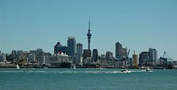
Auckland
From Wikipedia, the free encyclopaedia
| Auckland Tāmaki-makau-rau (Māori) | |
| - Main urban area - | |
 | |
| Nickname: City of Sails, Queen City (now rarely used) | |
 | |
| Coordinates ([1]): | |
|---|---|
| Country |  |
| Settled | ~ 1350 (early Maori) |
| ~ 1840 (first Europeans) | |
| Territorial Authorities | Names
|
| Government | |
| - Mayor(s) | Multiple
|
| - Regional Council | Auckland Regional Council |
| Area | |
| - Total | 1,086 km² (419 sq mi) |
| Population (June 2007 estimate)[2] | |
| - Total | 1,294,000 |
| - Density | 1,199.5/km² (3,106.7/sq mi) |
| - Demonym | Aucklander |
| Time zone | NZST (UTC+12) |
| - Summer (DST) | NZDT (UTC+13) |
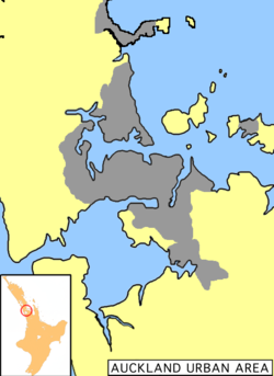
| Extent of Urban Area | North to Waiwera, northwest to Kumeu, east to Maraetai, south to Drury and Runciman; excludes Waitakere Ranges & Hauraki Gulf Islands |
| Website:http://www.aucklandnz.com/ | |
The Auckland metropolitan area or Greater Auckland, in the North Island of New Zealand, is the largest urban area of the country. It is also New Zealand's most populous city with approximately 1.3 million residents, over a quarter of the country's population, and demographic trends indicate that it will continue growing faster than the rest of the country. Auckland also has the largest Polynesian population of any city in the world.
It is a conurbation, made up of Auckland City (excluding the Hauraki Gulf islands), North Shore City, and the urban parts of Waitakere and Manukau cities, along with Papakura District and some nearby urban parts of Rodney and Franklin Districts. In Maori its name is Tāmaki-makau-rau, or the transliterated version of Auckland, Ākarana.
Auckland lies between the Hauraki Gulf of the Pacific Ocean to the east, the low Hunua Ranges to the south-east, the Manukau Harbour to the south-west, and the Waitakere Ranges and smaller ranges to the west and north-west. The central part of the urban area occupies a narrow isthmus between the Manukau Harbour on the Tasman Sea and the Waitemata Harbour on the Pacific Ocean. It is one of the few cities in the world to have harbours on two separate major bodies of water.
History
Early Maori and Europeans
The isthmus was first settled around 1350 and was valued for its rich and fertile land. Many pā (fortified villages) were created, mainly on the volcanic peaks. Maori population in the area is estimated at about 20,000 before the arrival of Europeans. The subsequent introduction of firearms, which began in Northland, upset the balance of power and led to devastating inter-tribal warfare, causing iwi, who lacked the new weapons, to seek refuge in areas less exposed to coastal raids. As a result, the region had relatively low numbers of Maori when European settlement of New Zealand began. There is, however, nothing to suggest that this was the result of a deliberate European policy.
After the signing of the Treaty of Waitangi in February 1840, the new Governor of New Zealand, William Hobson, chose the area as his new capital. Even in 1840, however, Port Nicholson (later Wellington), was seen as a better choice for an administrative capital because of its proximity to the South Island, which was being settled much more rapidly. At the same time, Auckland was the capital and principal city of the Auckland Province, remaining so until the provincial system was abolished in 1876. Immigration to the new city remained strong, however, even after it lost its status as national capital in 1865.
Growth up to today
Becoming a base against the Maori King Movement in the early 1860s and continued road building towards the south into the Waikato enabled Pākehā (European New Zealanders) influence to spread from Auckland. Its population also grew fairly rapidly, from 1,500 in 1841 to 12,423 by 1864. The growth occurred similarly to other mercantile-dominated cities, mainly around the port and with problems of overcrowding and pollution.
Trams and railway lines shaped Auckland's rapid expansion in the early first half of the 20th century, but soon afterward the dominance of the motor vehicle emerged and has not abated since; arterial roads and motorways have become both defining and geographically dividing features of the urban landscape. They also allowed further massive expansion that resulted in the growth of associated urban areas like the North Shore (especially after the construction of the Auckland Harbour Bridge), and Manukau City in the south.
A large percentage of Auckland is still dominated by a very suburban style of building, giving the city a very low population density. Although it has no more than a sixth of the population of London, it sprawls over an area almost as large (over 1,000 sq km), making public transport costlier than in other, high-density, cities.
Future growth
Auckland is expecting substantial population growth via immigration and natural population increases (which contribute to growth at about 1/3rd and 2/3rds, respectively), and is set to grow to an estimated 2 million inhabitants by 2050. This substantial increase in population will have a major impact on transport, housing and other infrastructure that is in many cases already considered under pressure. It is also feared by some organisations, such as the Auckland Regional Council, that urban sprawl will result from the growth and, as a result, that it is necessary to address this proactively in planning policy.
A 'Regional Growth Strategy' has been adopted that sees limits on further subdivision and intensification of existing use as its main sustainability measures. This policy is contentious, as it naturally limits the uses of private land, especially the subdivision of urban fringe properties, by setting 'Metropolitan Urban Limits' in planning documents like the District Plan.
A related issue is the current discussion about local government, with widely differing views. Some Aucklanders blame limited progress on Auckland's issues on poor governance and the fragmentation of the city into various councils (currently seven "City/District" authorities, plus one "Regional" authority). Others point to the fact that a previous integration of the many much smaller Borough Councils did not bring the promised advantages either, and reduced local participation in politics. In 2007, the government set up a Royal Commission of Inquiry which will report back on what restructuring should be done.
Geography and climate
 |
| Rangitoto island as seen from North Head |
Volcanoes
Auckland straddles the volcanoes of the Auckland Volcanic Field. The approximately 50 volcanic vents in the field take the form of cones, lakes, lagoons, islands and depressions, and several have produced extensive lava flows. Most of the cones have been partly or completely quarried away. The individual volcanoes are all considered extinct, although the volcanic field itself is merely dormant.
The most recent and by far the largest volcano, Rangitoto Island, was formed within the last 1000 years, and its eruptions destroyed the Maori settlements on neighbouring Motutapu Island some 700 years ago. Rangitoto's size, its symmetry, its position guarding the entrance to Waitemata Harbour and its visibility from many parts of the Auckland region make it Auckland's most iconic natural feature. Few birds and insects inhabit the island because of the rich acidic soil and the type of flora growing out of the rocky soil.
Harbours and Gulf
Auckland lies on and around an isthmus, less than 2 kilometres wide at its narrowest point, between Mangere Inlet and the Tamaki River. There are two harbours in the Auckland urban area surrounding this isthmus: Waitemata Harbour to the north, which opens east to the Hauraki Gulf, and Manukau Harbour to the south, which opens west to the Tasman Sea.
Bridges span parts of both harbours, notably the Auckland Harbour Bridge crossing the Waitemata Harbour west of the Auckland Central Business District (CBD). The Mangere Bridge and the Upper Harbour Bridge span the upper reaches of the Manukau and Waitemata Harbours, respectively. In earlier times, portage paths crossed the narrowest sections of the isthmus.
Several islands of the Hauraki Gulf are administered as part of Auckland City, though they are not officially part of the Auckland metropolitan area. Parts of Waiheke Island effectively function as Auckland suburbs, while various smaller islands near Auckland are mostly zoned 'recreational open space' or are nature sanctuaries.
Climate
 |
| View of the Auckland Central Business District. |
Auckland has a warm-temperate climate, with warm, humid summers and mild, damp winters. It is the warmest main centre of New Zealand and is also one of the sunniest, with an average of 2060 sunshine hours per annum. The average daily maximum temperature is 23.7 ºC in February, and 14.5 ºC in July, the absolute maximum recorded temperature is 30.5 ºC, while the absolute minimum is -2.5. High levels of rainfall occur almost year-round with an average of 1240 mm per year spread over 137 'rain days'. Climatic conditions vary in different parts of the city owing to geography such as hills, land cover and distance from the sea, hence unofficial Auckland temperature records exist, such as a maximum of 32.4 ºC in Henderson during February 1998. On 27 July 1939 Auckland received its only recorded snowfall.
The early morning calm on the isthmus during settled weather, before the sea breeze rises, was described as early as 1853: "In all seasons, the beauty of the day is in the early morning. At that time, generally, a solemn stillness holds, and a perfect calm prevails..." Many Aucklanders use this time of day to walk and run in parks.
As car ownership rates are very high and emissions controls relatively weak, Auckland suffers from some air pollution, especially in regards to fine particles emissions. There are also regular breaches of guideline levels of carbon monoxide. While maritime winds normally disperse the pollution relatively quickly it can sometimes become visible as smog, especially on calm winter days.
People
Cultures
Auckland is home to many cultures. The majority of inhabitants claim European - predominantly British - descent, but substantial Maori, Pacific Islander and Asian communities exist as well. Auckland has the largest Polynesian population of any city in the world and a higher proportion of people of Asian origin than the rest of New Zealand. Ethnic groups from all corners of the world have a presence in Auckland, making it by far the country's most cosmopolitan city.
Demographics
The proportion of Asians and other Non-European immigrants has increased during the last decades due to immigration, and the removal of restrictions directly or indirectly based on race. Immigration to New Zealand is heavily concentrated towards Auckland (partly for job market reasons). This strong focus on Auckland has led the immigration services to award extra points towards immigration visa requirements for people intending to move to other parts of New Zealand.
The following table shows the ethnic profile of Auckland's population, as recorded in the 2001 and 2006 New Zealand Census. The percentages add up to more than 100%, as some people counted themselves as belonging to more than one ethnic group. Figures for 2006 refer to the whole Auckland Region, not just the urban area. The substantial percentage drop of 'Europeans' was mainly caused by the increasing numbers of people from this group choosing to define themselves as 'New Zealanders' - even though this was not one of the groups listed on the census form.
| Ethnic Group | 2001 (%) | 2001 (people) | 2006 (%) | 2006 (people) |
|---|---|---|---|---|
| European | 66.9 | 684,237 | 56.5 | 698,622 |
| Pacific Island | 14.9 | 152,508 | 14.4 | 177,936 |
| Asian | 14.6 | 149,121 | 18.9 | 234,222 |
| Māori | 11.5 | 117,513 | 11.1 | 137,133 |
| Middle East/Latin America/Africa | n/a | n/a | 1.5 | 18,555 |
| Others | 1.3 | 13,455 | 0.1 | 648 |
| 'New Zealanders' | n/a | n/a | 8.0 | 99,258 |
| Total giving their ethnicity | 1,022,616 (individuals) | 1,237,239 (individuals) |
The 2006 Census also provides information about the multilinguality of the region. Accordingly, 867,825 people in the Auckland Region spoke one language only, while 274,863 spoke two, and 57,051 could converse in three or more languages.
Religion
Similar to the rest of the country, over half of Aucklanders profess Christianity, but fewer than 10% regularly attend church and almost 40% profess no religious affiliation (2001 census figures). The main denominations are Roman Catholic, Anglican and Presbyterian. Pentecostal and charismatic churches are the fastest growing. A higher percentage of Polynesian immigrants are regular churchgoers than other Aucklanders. Recent immigration from Asia has added to the religious diversity of the city, so now about 10% of the population follow such beliefs as Buddhism, Hinduism, Islam and Sikhism, although there are no figures on religious attendance. There is also a small, long-established Jewish community.
Lifestyle
Positive aspects of Auckland life are its mild climate, plentiful employment and educational opportunities, as well as numerous leisure facilities. Meanwhile, traffic problems (compared to other New Zealand cities), the lack of good public transport, and increasing housing costs have been cited by many Aucklanders as among the strongest negative factors of living there, together with crime. Nonetheless, Auckland current ranks 5th in a survey of the quality of life of the world's top 55 cities (2007 data, rank unchanged from 2006). In 2006, Auckland placed 23rd on the UBS list of the world's richest cities.
Leisure
 |
| City Of Sails - View over the Westhaven Marina. |
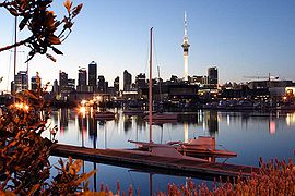
Auckland is popularly known as the "City of Sails" because the harbour is often dotted with hundreds of yachts and has more per capita than any other city in the world, with around 135,000 yachts and launches estimated. Around 60,500 of the country's 149,900 registered yachtsmen also come from the Auckland Region. Viaduct Basin also hosted two America's Cup challenges (2000 Cup and 2003 Cup), and its cafes, restaurants, and clubs add to Auckland's vibrant nightlife. With the sheltered Waitemata Harbour at its doorstep, Auckland sees many nautical events, and there are also a large number of sailing clubs in Auckland, as well as Westhaven Marina, the largest of the Southern Hemisphere.
 |
| Auckland - Skyline from Westhaven Marina. |
High Street, Queen Street, Ponsonby Road, and Karangahape Road are also very popular with urban socialites. Newmarket and Parnell are up-market shopping areas, while Otara's and Avondale's famous fleamarkets and Victoria Park Market offer a colourful alternative shopping experience. Newer shopping centre-type developments in the Auckland area tend to be outside of the older city centres, with Sylvia Park (Sylvia Park, Auckland City), Botany Town Centre (Howick, Manukau City) and Westfield Albany (under construction as of 2007) (Albany, North Shore City) being the three largest.
The Auckland Town Hall and Aotea Centre host conferences and cultural events such as theatre, kapa haka, and opera. Auckland also boasts a symphonic ensemble in the Auckland Philharmonia Orchestra.
Many national treasures are displayed at the Auckland Art Gallery, such as the work of Colin McCahon. , while many other significant cultural artefacts reside at the Auckland War Memorial Museum, the National Maritime Museum, or the Museum of Transport and Technology (MOTAT). Exotic creatures can be observed at the Auckland Zoo and Kelly Tarlton's Underwater World. Movies and rock concerts (notably, the "Big Day Out") are also well patronised.
Parks and nature
Auckland Domain is one of the largest parks within the city, situated close to the CBD and having a good view of the Gulf and of Rangitoto island. Smaller parks also close to the city centre are Albert Park, Myers Park, Western Park and Victoria Park.
While most volcanic cones in the Auckland Volcanic Field have been affected by quarrying, many of the remaining cones are now ensconced within parks, and retain a somewhat more natural character than the surrounding city. Prehistoric earthworks and historic fortifications feature in several of these parks, including Mount Eden, North Head and One Tree Hill (Maungakiekie).
Other parks around the city are in Western Springs, which has a large park bordering on the MOTAT museum and the Auckland Zoo. The Auckland Botanic Gardens are located further south in Manurewa.
Ferries provide transport to parks and nature reserves at Devonport, Waiheke Island and Rangitoto Island. The Waitakere Ranges Regional Park to the west of Auckland offers beautiful and relatively unspoiled bush territory, as do the Hunua Ranges to the south.
Sport
Locations
The most popular sports in Auckland and New Zealand in general are cricket and rugby. Auckland has a considerable number of rugby and cricket grounds, and venues for motorsports, tennis, badminton, netball, swimming, soccer, rugby league, and many other sports.
- ASB Tennis Centre is Auckland's premier tennis centre hosting international tournaments for men (Heineken Open) and women (ASB Classic) in January each year.
- Eden Park is the city's primary stadium and a frequent home for All Blacks rugby union and Black Caps cricket matches.
- Mt Smart Stadium is used mainly for rugby league and soccer matches, but also used for concerts.
- North Harbour Stadium is mainly used for rugby league, rugby and soccer but it is also used for concerts.
- Vector Arena is a new multi-purpose indoor arena, though its comparatively small field will prevent some types of sports from being played here.
- Western Springs Stadium is a natural amphitheatre used mainly for speedway races, rock and pop concerts.
- Trusts Stadium is where the 2007 Netball World Championships were held and where many netball games are held.
Waitemata Harbour has popular swimming beaches at Mission Bay, Devonport, Takapuna, Long Bay and Maraetai, and the west coast has popular surf spots such as Piha and Muriwai. Many Auckland beaches are patrolled by surf lifesaving clubs, which are part of Surf Life Saving Northern Region.
Main teams
The Auckland rugby franchise The Blues, formerly known as the 'Auckland Blues' is one of the more successful of New Zealand's five Super 14 franchises. Many All Blacks have also come from Auckland.
Cricket also has a strong following in Auckland. The Auckland cricket franchise, the Auckland Aces won the State Shield Trophy against the Otago Volts in February 2007. The Aces had narrowly lost against the Canterbury Wizards the previous year.
Previously known as the Auckland Warriors, the New Zealand Warriors represent New Zealand in Australia's National Rugby League competition. They play their home games at Mt Smart Stadium in Auckland. Their most successful year came in 2002 when they finished Minor Premiers and qualified for the Grand Final. If the National Rugby League expands to include a Wellington side it is expected that the Warriors will revert back to being the Auckland Warriors or simply the Warriors.
Major events
Popular annual sporting events include:
- The 'Harbour Crossing' swim from Devonport to the Viaduct Basin, Auckland CBD, is a yearly summer event, covering 2.8 km (often with some considerable counter-currents) and attended by over a thousand mostly amateur competitors. It is New Zealand's largest ocean swim.
- The 'Round the Bays' fun-run, starting in the city and going 8.4 kilometres (5.2 miles) along the waterfront to the suburb of St Heliers. It attracts many tens of thousands of people and has been an annual March event since 1972.
- The Auckland Marathon (and half-marathon), an annual competition for thousands of enthusiasts.
Economy
Most major international corporations have an Auckland office, as the city is seen as the economic capital of the nation. The most expensive office space is around lower Queen Street and the Viaduct Basin in the Auckland CBD, where many financial and business services are located, which make up a large percentage of the CBD economy. A large proportion of the technical and trades workforce is based in the industrial zones of South Auckland.
The largest commercial and industrial areas of Greater Auckland are in the southeast of Auckland City as well as in the western parts of Manukau City, mostly in the areas bordering the Manukau Harbour and the Tamaki River estuary.
Auckland's status as the largest commercial centre of the county reflects in the high median personal income (per working person, per year) which was NZ$44,304 (approx. US$33,000) for the region in 2005, with jobs in the Auckland CBD often earning more. The median personal income (for all persons older than 15 years of age, per year) was NZ$22,300 (2001), behind only North Shore City (also part of the Greater Auckland area) and Wellington. While office workers still account for a large part of Auckland's commuters, large office developments in other parts of the city, for example in Takapuna or Albany, both North Shore City, are slowly becoming more common, reducing concentration on the Auckland CBD somewhat.
Education
Auckland has a number of important educational institutions, including some of the largest universities in the country. Auckland is also known to be a major centre of overseas language education, with large numbers of foreign students (particularly East Asians) coming to the city for several months or years to learn English or study at universities - although numbers New Zealand-wide have dropped substantially since peaking in 2003.[38] As of 2007, there are around 50 NZQA certified schools and institutes teaching English in the Auckland area.
Auckland has a multitude of primary and secondary schools, with the Auckland Grammar School (for boys) , Mount Albert Grammar School, Auckland Girls' Grammar School and the Epsom Girls' Grammar School being amongst the most famous. The city also has several private schools such as the exclusive King's College, Auckland International College and Diocesan School for Girls. Auckland contains New Zealand's three largest (by full-time student numbers) high schools: Rangitoto College, Avondale College and Manurewa High School respectively.
Amongst the most important tertiary educational institutes are the University of Auckland (city and Tamaki Campus), Auckland University of Technology (city campus), Massey University (Albany campus) and the Manukau Institute of Technology (Otara campus), with Unitec New Zealand (Mt Albert campus) being the largest technical institute in Auckland.
Housing
Housing varies considerably between some suburbs having state owned housing in the lower income neighbourhoods, to palatial waterfront estates, especially on the Waitemata. Traditionally, the most common residence of Aucklanders was a bungalow on a 'quarter acre' (1,000 m²), however subdividing such properties with 'infill housing', has long been the norm. Aucklanders' housing preferences have resulted in a large urban sprawl and reliance on motor vehicles. This will likely continue, as the vast majority of Aucklanders live in low-density housing, which is expected to remain at up to 70% of the total share even in 2050.
In some areas, the Victorian villas are being increasingly torn down to make way for large plaster mansions with tennis courts and swimming pools. The rampant demolition of the older properties is being combated by the Auckland City Council passing laws that cover heritage suburbs or streets. Auckland has been described as having 'the most extensive range of timbered housing with its classical details and mouldings in the world', many of them Victorian-Edwardian style houses.
Transport
Travel modes
Road and rail
Auckland is highly dependent on private vehicles as the main form of transportation, with only around 5% of all journeys in the Auckland region being undertaken by bus. This results in substantial traffic congestion during peak times.
Bus services in Auckland are mostly radial rather than ring-routes, due to Auckland being on an isthmus. Late-night services (i.e. past midnight) are limited, even on weekends. Train services are mainly limited to some commuter services routes to the west and southeast of Auckland, with longer-distance options scarce. Currently (2007) approximately NZ$ 5.3 billion worth of large-scale projects are underway or planned (and budgeted for) in the Auckland area to improve rail and public transport patronage over the next decade, a share of 31% of the whole transport budget.
Other modes
Auckland's ports are the largest of the country, and a large part of both inbound and outbound New Zealand commerce travels through them, mostly via the facilities located to the northeast of the Auckland City CBD. Freight usually arrives / is distributed from the port via road, though the port facilities also have rail access. Auckland is also a major cruise ship stopover point, with the ships usually tying up at Princes Wharf. Auckland CBD is also connected to various outlying coastal suburbs, to North Shore City and to outlying islands by ferry.
Auckland has various small regional airports as well as Auckland International Airport, the busiest of the country.
Policies
Research at Griffith University has indicated that in the last 50 years, Auckland has engaged in some of the most pro-automobile transport policies anywhere in the world. With public transport declining heavily in usage and provision during the second half of the 20th century (a trend mirrored in most Western countries such as the US), and increased spending on roads and cars, New Zealand (and specifically Auckland) now has the second-highest vehicle ownership rate in the world, with around 578 vehicles per 1000 people.
Infrastructure
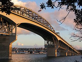 |
| The harbour bridge from North Shore City. |
The State Highway network connects the cities located in the Auckland urban area, the most frequently travelled being the Northern, Southern, Northwestern and Southwestern Motorways.
The Auckland Harbour Bridge (Northern Motorway) is the main connection to North Shore City, and also a major road bottleneck. The Central Motorway Junction, also called 'Spaghetti Junction' for its complexity, forms the intersection between the two major motorways of Auckland (State Highway 1 and State Highway 16) as well as connecting them to the surrounding parts of the city.
Two of the longest arterial roads within Greater Auckland are Great North Road and Great South Road - the main connections in those directions before the construction of the State Highway network.
Auckland has three main railway lines, serving the general western, southern, and central eastern directions from the Britomart Transport Centre. Located in downtown Auckland, it is the terminal station for all lines, and connects them to ferry and bus services.
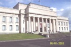
Famous sites
 |
| The Auckland War Memorial Museum. |
The following is a list of tourist attractions and landmarks in the Auckland metropolitan area:
Attractions and Buildings
- Auckland Civic Theatre - a famous heritage atmospheric theatre in downtown Auckland. It is still operating as a theatre and was renovated in 2000 to its original condition.
- Harbour Bridge - connecting Auckland and the North Shore, an iconic symbol of Auckland.
- Auckland Town Hall - with its concert hall considered to have some of the finest acoustics in the world, this 1911 building serves both Council and entertainment functions.
- Auckland War Memorial Museum - a large multi-exhibition museum in the Auckland Domain, known for its impressive neo-classicist style.
- Aotea Square - the hub of downtown Auckland besides Queen Street, it is often the site of crafts markets, rallies or arts festivals.
- Britomart Transport Centre - the main downtown public transport centre located in a historic Edwardian building.
- Eden Park - the city's primary stadium and a frequent home for All Blacks rugby union and Black Caps cricket matches.
- Karangahape Road - known as "K' Road", a street in upper central Auckland famous for its bars, clubs and smaller shops.
- Kelly Tarlton's Underwater World - a well-known aquarium in the eastern Mission Bay suburb, built in a set of former sewage storage tanks, and showing fish like sharks.
- MOTAT - Auckland's Museum for Transport and Technology, at Western Springs.
- Mt Smart Stadium - a stadium used mainly for rugby league and soccer matches. Also the site of many concerts.
- Ponsonby - a suburb and main street west of central Auckland known for arts, cafes and culture.
- Queen Street - the main street of the city, from Karangahape Road down to the harbour. Somewhat rundown, it is currently (2006-2008) undergoing extensive works.
- Sky Tower - the tallest free-standing structure in the Southern Hemisphere, it is 328 m (1,076 ft) tall and has excellent panoramic views.
- Vector Arena - events centre in downtown Auckland completed in 2007. Holding 12,000 people, it can be used for sports and concert events.
- Viaduct Basin - a marina and residential development in downtown Auckland, the venue for the America's Cup regattas in 2000 and 2003.
- Western Springs Stadium - a natural amphitheatre used mainly for speedway races, rock and pop concerts.
Landmarks and Nature
- Auckland Domain - one of the largest parks of the city, close to the CBD and having a good view of the harbour and of Rangitoto Island.
- Mount Eden - a volcanic cone with a grassy crater. As the highest natural point in Auckland City, it offers 360-degree views of Auckland and is thus a favorite tourist outlook.
- Mount Victoria - a volcanic cone in North Shore City offering a spectacular view of Auckland. A brisk walk from the Devonport ferry terminal, the cone is steeped in history, as is nearby North Head.
- One Tree Hill (Maungakiekie) - a volcanic cone that dominates the skyline in the southern, inner suburbs. It no longer has a tree on the summit (after a politically motivated attack on the old tree) but is still crowned by an obelisk.
- Rangitoto Island - guards the entrance to Waitemata Harbour, and forms a prominent feature on the eastern horizon.
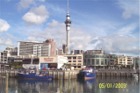
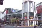
Photos from Auckland New Zealand
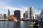 Auckland Ferry Terminal from Princes Wharf |
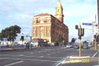 Auckland Ferry Building |
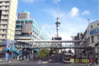 Auckland Skytower from Princess Warf |
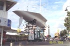 KZ1 Racing Yacht |
 Auckland Skytower from Viaduct Harbour |
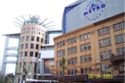 Skycity Metro Cinema Queenstreet Auckland |
 Skycity Casino and Skytower Auckland |
 Auckland War Memorial Museum |
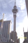 Auckland Skytower |
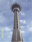 Auckland Skytower |
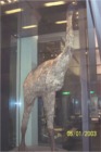 Moa Bird - Auckland Museum |
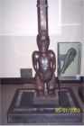 Maori Carving - Auckland Museum |
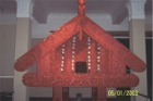 Maori Pataka (Storage House for Food) |
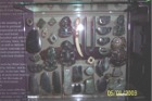 Maori Greenstone Tiki and other Pendants |
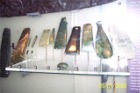 Maori Greenstone Artifacts |
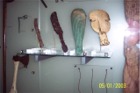 Maori Patu (short fighting clubs) |
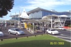 Auckland Airport |
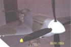 Spitfire Fighter - Auckland Museum |
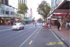
 Queen Street Auckland |
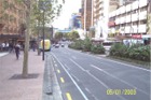
 Lower Queen Street Auckland |


![]()