Wellington New Zealand Information
Home > New Zealand Information > Wellington Information
Wellington
From Wikipedia, the free encyclopaedia
Wellington is the capital city of New Zealand and the second largest metropolitan area. Wellington is known for its picturesque natural harbour and green hillsides adorned with tiered suburbs of colonial villas. Wellington stands alongside Melbourne as a cultural centre of Australasia, with a thriving arts scene, cafe culture and buzzing nightlife that easily rivals cities of ten times its size.
Location and Demographics
| Wellington | ||
|---|---|---|
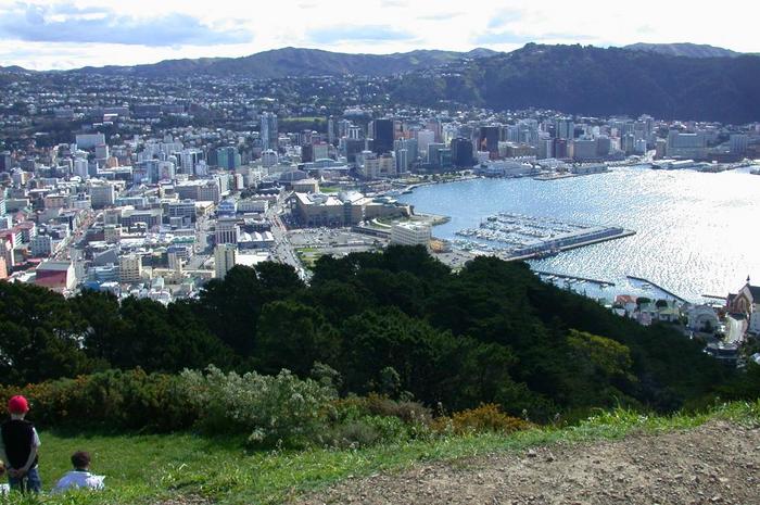 A view of Wellington from the top of Mount Victoria. In the middle of the image you can see the internationally famous Te Papa museum |
||
| Urban Area | Population | 363,400 |
| Extent | North to Pukerua Bay & Te Marua, including Pauatahanui; excludes Makara, Ohariu, Paekakariki Hill and rural areas of the Hutt Valley. |
|
| Territorial Authority |
Name | Wellington City |
| Population | 179,100 (2003) | |
| Land area | 290km² | |
| Extent | North to Tawa; includes Makara and Ohariu |
|
| Mayor | Kerry Prendergast | |
| See also | Porirua City Upper Hutt City (Lower) Hutt City |
|
| Regional Council |
Name | Wellington |
Wellington is located at the southwestern tip of the North Island on Cook Strait, the passage that divides the North and South Islands. On a clear day the snow-capped Kaikoura Ranges are visible like a white ghost across the strait. To the north are the golden beaches of the Kapiti Coast. On the east the Rimutaka Range divides Wellington from the broad plains of the Wairarapa, a wine region of worldwide acclaim.
Wellington has an estimated urban area population of 363,400 (June 2003), including the satellite cities of Upper Hutt, Lower Hutt, and Porirua. The area administered by the Wellington City Council includes 1,100 people who live outside the urban area in the adjacent rural communities of Makara and Ohariu.
The average annual rainfall in the city is 1270mm.
It is the southernmost national capital city in the world with a latitude about 41 degrees south. It is more densely populated than most other settlements in New Zealand, due to the small amount of building space available between the harbour and the surrounding hills.
On the hill west of the city centre, near Victoria University, is a botanic garden, and both can be reached on a funicular railway (the "cable car").
History
Settlement
Originally settled by the Maori, Wellington was known in Maori legend as Te Upoko o te Ika a Maui, meaning "the head of Maui's fish" and is said to have been discovered by Kupe in the 10th century.
European settlement began with the arrival of an advance party of the New Zealand Company on the ship Tory, on 20 September 1839, followed by 150 settlers on the ship Aurora on 22 January 1840. Their settlement was named after Arthur Wellesley, 1st Duke of Wellington. According to legend it was originally named "Britannia" and constructed on the flat area at the mouth of the Hutt River (now Petone) but when this was found to be too swampy and flood-prone the plans were transplanted without regard for a more hilly terrain -- Wellington has some extremely steep streets running straight up the sides of hills.
Earthquakes
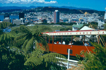
Wellington New Zealand Cable Car & Panorama
Wellington was seriously damaged by a series of earthquakes in 1848 and another earthquake in 1855. The event in 1855 is now known as the Wairarapa earthquake and occurred on a fault line to the north or east of Wellington. It was probably the most powerful earthquake in recorded New Zealand history, with an estimated magnitude of at least 8.2. It caused vertical movements of 2 to 3 metres to land over a large area, including raising an area of land out of the harbour and turning it into a tidal swamp. Much of this land was subsequently reclaimed and is now part of Wellington's central business district. This is the reason why the street named Lambton Quay is now 100-200 metres from the harbour. There are a number of plaques set into the footpath on Lambton Quay, at major intersections, that indicate where the shoreline was located in 1840 to show the extent of the uplift.
The area has high seismic activity even by New Zealand standards, with a major fault line running through the centre of the city and several others nearby. Several hundred more minor fault lines have been identified within the urban area. Typically at least one earthquake is noticed by the inhabitants every year, particularly in the high-rise office buildings in the city. For many years after the 1855 earthquake, the majority of buildings constructed in Wellington were made entirely from wood. The recently restored Government Buildings, between the Railway Station and Parliament Buildings is the largest wooden office building in the Southern Hemisphere. While masonry and structural steel have subsequently been used in building construction, especially office buildings, timber framing is still the primary structural component of almost all residential construction. Residents also place their hopes of survival in good building regulations, which were gradually tightened during the 20th century.
NZ's Capital
In 1865 Wellington became the capital of New Zealand, replacing Auckland where William Hobson had established his capital in 1840. Parliament first sat in Wellington on 7 July, 1862, but the city did not become the official capital for some time. In November 1863 Alfred Domett moved a resolution before Parliament (in Auckland) that "it has become necessary that the seat of government...should be transferred to some suitable locality in Cook Strait." Apparently there was concern that the southern regions, where the goldfields were located, would form a separate colony. Commissioners from Australia (chosen for their neutral status) were of the opinion that Wellington was suitable because of its harbour and central location. Parliament officially sat in Wellington for the first time on 26 July 1865. The population of Wellington was then 4900. (reference Phillip Temple, Wellington Yesterday).
Wellington attained city status in 1886.
Educational facilities
Victoria University, Wellington's oldest university has its main campus in the hill suburb of Kelburn overlooking the centre of the city, but also has two major downtown campuses. It was originally established as a constituent college of the University of New Zealand.
The University of New Zealand used to be based at Senate House on Bowen Street until its dissolution in 1961.
There is also a branch of Massey University in Wellington, taking over the former Wellington Polytechnic. The campus is based at the previous national museum that has been replaced by the Te Papa ("Our Place") Museum. Massey's involvement with Wellington began with the merger with the Wellington Polytechnic School.
The oldest secondary school in Wellington is the Wellington College, and is a nationally recognised school in terms of producing Governors-General, military Generals, business leaders and other leaders.
One of the major secondary schools in Wellington is Wellington High School, with the number of enrolled students hovering around 1200. It is also notable for being the only co-educational school in the central city. It used to be joined to the Polytech as the "Wellington Technical College" but later split


![]()